Afternoon storm risk is the line that matters. Everything else is comfort. In summer, plan to be off the ridge before the build-up starts, not as it starts. Forecast for the summit point, adjusted for its elevation · data from Open-Meteo.
Standard route · East Slope
Overview
Mount Democrat is the western peak of the group above Kite Lake, near Alma. It is often the first summit on the popular loop that also takes in Cameron, Lincoln and Bross. The trailhead starts high, at 12,000 feet, so the climb is short: about 4 miles round trip with 2,150 feet of gain. Most people take 3 to 4 hours for Democrat alone.
The route follows a trail past an old mine up Democrat's east slope to the saddle between Democrat and Cameron, then climbs a steeper, rocky slope to the summit ridge. It is Class 2 because of the rough, loose rock on the upper slope, but the trail is clear almost all the way.
Because the day is short, people tend to take it lightly. You start above treeline and never leave it, so there is no shelter from lightning. The saddle and ridge are very windy, and the loose rock on the upper slope is easy to slip on coming down. Summer weekends are crowded.
Plan of the day
Start by
By 6 a.m. The climb is short but you are above treeline from the first step, and storms often build over the Mosquito Range by late morning. Parking also fills early.
Turnaround
Be at the Democrat-Cameron saddle (about 13,400 feet) by 10:30 a.m. If you are not, or if clouds are building, turn around there.
Crux
The long, steep traverse and switchbacks above the saddle on loose, rocky ground up to the summit ridge near 13,900 feet.
Route-finding
Easy on a clear day. The trail is obvious up to the saddle and up the slope. The ridge near the top has a lower high point that can look like the summit; keep going along the ridge to the true top.
Water
Kite Lake and its inlet streams are at the trailhead. There is no reliable water on the route above the lake. Bring what you need from the car, or filter or treat lake water.
Follow Colorado 9 into Alma. Near the center of town, watch the west side of the highway for a small Kite Lake road sign. Turn there, pass a short row of houses, and keep going about 6 miles up the Buckskin Gulch road until you reach Kite Lake.
The road is dirt and gets rougher in the last mile. A higher-clearance 2WD vehicle can usually get to within a couple hundred yards of the lot when the road is dry; low cars may need to park lower and walk. The trailhead has restrooms and some campsites, and a day-use fee is charged. Arrive early on summer weekends.
TundraTalus and screeRidgeExposed to lightning
The line is elevation, the band underneath is the ground, and the numbered dots match the steps below. Mileage and elevations are approximate.
1
Kite Lake trailhead 12,000' · 0 mi
From the parking area, walk north on the blocked old road past Kite Lake and a few campsites. Democrat is the peak on your left; Cameron and Lincoln are ahead and to the right.
2
Above the lake 12,150' · 0.2 mi
The road turns into a trail and climbs gently north up the valley over tundra.
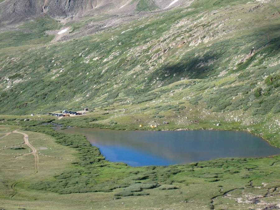
Kite Lake from the Democrat trail · Photo: Kevin R Foote
3
Kentucky Belle Mine 12,400' · 0.5 mi
You reach the ruins of the old Kentucky Belle Mine. Stay on the main trail as it turns onto Democrat's east slope.
Watch for: Stay out of old mine structures and openings.
4
Rugged slope 12,600' · 0.7 mi
The trail climbs a rougher, rocky slope. The footing is uneven but the path is easy to see.
5
Switchbacks 12,800' · 0.85 mi
A few switchbacks take you up the slope. The saddle between Democrat and Cameron is now in view ahead to the north.
6
Turn north 13,000' · 1 mi
At about 13,000 feet the trail turns right and heads north across Democrat's east slope toward the saddle.
7
Across the east slope 13,200' · 1.15 mi
The trail crosses the slope on a steady grade. Stay on the path; the ground is fragile and the loose slope below is easy to slide on.
8
Democrat-Cameron saddle 13,400' · 1.3 mi
A broad, windy saddle. Turn left and head west up the ridge toward Democrat.
Watch for: Check the time and weather here. This is your turnaround point.
9
Up the ridge 13,600' · 1.4 mi
Follow the trail west up the ridge for about 200 feet of climbing. Then the trail turns left and starts a long traverse southwest across the slope.
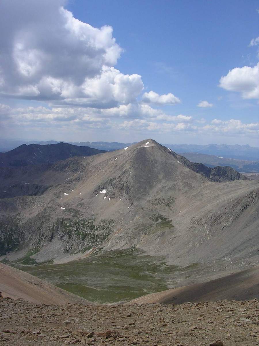
Mount Democrat · Photo: Mofussy
10
Long traverse 13,700' · 1.6 mi
The trail angles across much of the east slope of the summit block on loose, rocky ground.
Watch for: Loose rock on the traverse is slippery on the descent.
11
Top switchbacks 13,850' · 1.75 mi
The slope gets steeper and a few short switchbacks lead to the top of it.
12
Summit ridge 13,900' · 1.85 mi
You reach the summit ridge. A rocky high point here can look like the top; the real summit is a bit farther along.
13
Final pitch 14,050' · 1.95 mi
Walk over to the last short climb and follow the trail up it.
14
Summit 14,154' · 2 mi
A rocky summit with views west to the Sawatch Range and northwest toward the Climax mine. Cameron, Lincoln and Bross are to the east.
Here an unmarked path goes off to the right. Turn left to follow Mount Democrat Trail.
Coming down: Turn right to stay on Mount Democrat Trail. Don’t take the unmarked path.
Landmarks to know
Kite Lake right beside the parking area.
The ruins of the Kentucky Belle Mine near 12,400 feet.
A right turn onto a northbound traverse at about 13,000 feet.
The broad Democrat-Cameron saddle at about 13,400 feet.
A long southwest traverse across the upper slope.
A lower rocky high point on the summit ridge before the true top.
Getting down
Go back the same way. From the summit, return along the ridge and down the switchbacks and traverse to the saddle. The loose rock on the traverse is the most common place to slip, so slow down and use poles if you have them. Stay on the trail rather than cutting straight down toward the saddle.
At the saddle, turn right and follow the trail south back down Democrat's east slope, past the mine and down to Kite Lake. Do not drop straight off the saddle into the basin; the slopes are loose and easily damaged. If you continue on the loop, the trail up Cameron goes north from the saddle; only do that if the weather is good.
If things go wrong
The trail back to Kite Lake is the bail route, and it is short. From the saddle you are about 1.3 miles from the car. If a storm moves in, get off the summit ridge and back to the saddle, then keep going down; do not stop on the saddle, which is the exposed low point between two peaks. If someone is hurt, keep them warm and out of the wind. The route is busy, so ask others for help, and call 911 if needed.
3D flyover
Press play to fly the East Slope. The graph shows elevation along the way and how much you gain each mile. Open full screen.
For planning only. The line is traced from open map data, not walked in the field, and off-trail parts are drawn straight. Load it in your GPS app to see the route, but navigate with your eyes, a map and the route description.
See the trail on video
A climb of this route filmed by Scott Thomas. The video belongs to them and only plays when you press play.
Jump to
Other routes
All 3 routes up Mount Democrat, with the class and round-trip distance for each.
Mount Democrat → Mount Cameron → Mount Lincoln → Mount Bross
Class 2 still means loose rock and route-finding
Expect talus, scree and stretches where the trail disappears. Ankles and weather cause most of the trouble here. Start early, keep an eye on the sky, and set a turnaround time before you leave the car.