Afternoon storm risk is the line that matters. Everything else is comfort. In summer, plan to be off the ridge before the build-up starts, not as it starts. Forecast for the summit point, adjusted for its elevation · data from Open-Meteo.
Centennial 13er · East Ramp
Overview
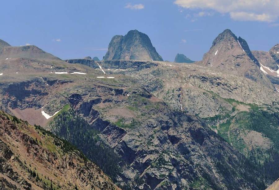
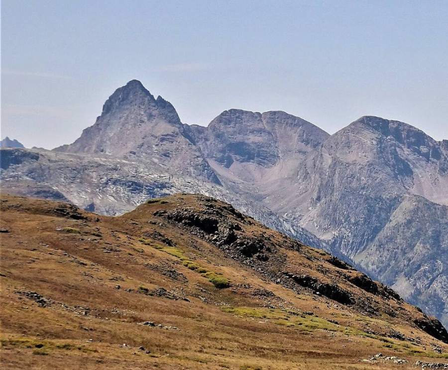
Arrow Peak is one of the most striking summits in the Grenadier Range, deep in the Weminuche Wilderness south of Silverton. It stands next to Vestal Peak above Vestal Creek. The climb follows a huge tilted ramp of slabby rock that sweeps up the east face, then finishes in a steep gully and a short, rocky ridge. The views of Vestal Peak's Wham Ridge and the rest of the Grenadiers are among the best in Colorado.
Getting there is a big part of the effort. From Molas Pass you drop about 1,700 feet to the Animas River, climb up Elk Creek, then take a steep, rough, unmaintained trail up Vestal Creek to camp. Most people take at least three days. The climb itself starts with a talus cone, then over 1,000 feet of steep slab on the ramp that is mostly solid but slick when wet. Near the top the ramp splits into gullies with a rock rib between them. The upper gully is steep Class 3, and some climbers find a move or two feels harder. There is moderate exposure in short sections. This is only for experienced scramblers who are strong backpackers.
The full trip is about 24 miles round trip with about 6,700 feet of gain. From a high camp on Vestal Creek, the climb is about 3 miles each way; plan on 5 to 7 hours round trip from camp. Help is very far away.
Plan of the day
Start by
By 5 a.m. from a camp on upper Vestal Creek. The ramp is a bad place to be when rain makes the slabs slick, and storms often build by late morning.
Turnaround
If you are not at the base of the ramp by 8 a.m., or at the point where the ramp splits (about 13,600 feet) by 10:30 a.m., turn around. Turn around at once if it starts to rain.
Crux
The steep gully above the point where the ramp splits, near 13,600 feet. It is steep Class 3 on rock with some exposure, then a short Class 3 scramble on the north ridge to the summit.
Route-finding
The Elk Creek trail is clear. The Vestal Creek trail is steep and confusing, with many branches and fallen logs; avoid side paths that lead into the avalanche chute. On the peak, the ramp is obvious once you see it from the valley between Arrow and Vestal. Near the top, pick your gully with care; cairns may help.
Water
The Animas River, Elk Creek and Vestal Creek all have water. There is little water on the ramp. Fill up at camp and filter or treat all water.
From Silverton, drive south on US 550 toward Molas Pass for about 5.3 miles. The Molas trailhead parking is on the left, about 0.6 mile past the turnoff for Molas Lake. From Durango, drive north over Coal Bank Pass and Molas Pass; the trailhead is about 1.1 miles past the top of Molas Pass, on the right. The dirt lot is fine for any car but can have potholes and mud.
Some people ride the Durango and Silverton train to the Elk Park stop instead, which skips the drop from Molas Pass and the climb back out. Check with the railroad for current schedules and stops. Either way, the hike continues up the Elk Creek trail and the Vestal Creek trail to camp. Plan for a long backpack in and out.
Trail in the treesTalus and screeTundraScramblingExposed to lightning
The line is elevation, the band underneath is the ground, and the numbered dots match the steps below. Mileage and elevations are approximate.
1
Molas trailhead 10,630' · 0 mi
Take the connector trail south to join the Colorado Trail. Head east through open meadows with wide views of the Grenadier Range to the south.
2
Colorado Trail meadows 10,650' · 1 mi
The trail stays roughly level through meadows and forest before it starts to drop. The Animas River canyon opens below you.
3
Animas River bridge 8,930' · 3 mi
The trail switchbacks down more than 30 times, losing about 1,700 feet. Cross Molas Creek, then the Animas River on a solid footbridge. Walk south along the train tracks a short way and watch for the Elk Creek trail climbing the slope on your left.
Watch for: Stay off the tracks when trains are running. You will climb back up these switchbacks at the end of the trip.
4
Elk Creek trail 9,200' · 3.8 mi
The trail switchbacks up, then contours over a low ridge into the Elk Creek valley. It stays on the north side of Elk Creek.
5
Bench above Elk Creek 9,900' · 5.8 mi
About a mile before the beaver ponds, the trail climbs above the creek, briefly up a side drainage, and onto a flatter bench high above the creek.
Watch for: A few spots where the trail crosses sloping, eroded banks.
6
Beaver ponds 9,980' · 6.5 mi
You will see the beaver ponds to the right of the trail. A side trail follows the east shore of the largest pond, below a boulder field, to flat campsites past it.
7
Elk Creek crossing 9,900' · 6.7 mi
Continue south to a steep bank above Elk Creek and cross the creek, often on fallen logs. Then follow a bench west before the trail turns uphill into the Vestal Creek drainage.
Watch for: Log crossings can be slick and change from year to year.
8
Vestal Creek trail 10,700' · 7.7 mi
The trail climbs steeply south through forest with many fallen logs and several branches. At an avalanche chute, stay on the main trail that climbs along a small ridge on the east side of the chute. Avoid a lower path toward the bottom of the chute.
Watch for: The side path into the chute leads to a bushwhack. Stay on the main trail.
9
Lower meadow 11,300' · 8.7 mi
The trail reaches a meadow near the creek, then continues into forest and out to the lower meadow. There are campsites here. Arrow and Vestal rise to the south.
10
Upper Vestal Creek camp 11,760' · 9 mi
Continue about a third of a mile to campsites in the last open trees by the creek. This is a good base for the climb. Marmots here are bold and will chew on gear, packs and anything salty.
Watch for: Protect food and gear from marmots.
11
Valley between Arrow and Vestal 12,000' · 10 mi
Contour west from camp across rock benches, grassy shelves and tundra into the valley between Arrow and Vestal. Look across at Arrow's east face and find the big ramp that sweeps up and to the right toward the summit.
Watch for: Check the sky. The ramp is dangerous when wet.
Vestal and Arrow from the valley · Photo: Doug Lynne
12
Base of the ramp 12,200' · 10.6 mi
At the northeast end of the ramp, climb a talus cone to reach the rock. Put your helmet on here. Move into the upper, western part of the ramp near its bottom rather than staying on its eastern edge.
13
The ramp 12,900' · 11.2 mi
Climb more than 1,000 feet of steep, slabby rock. Most of it is solid Class 2+, with some loose rock and short scrambles. Some rock is polished smooth. Keep to the right of any snow early in the season.
Watch for: Wet or polished slabs are very slick. Do not climb the ramp in rain.
14
Ramp splits 13,600' · 11.7 mi
The ramp turns more to the west, steepens, and splits into two gullies with a rock rib between them. Pick the gully that is free of snow, or climb on the rib where it is easier. Cairns may mark the way.
Watch for: Key decision point. If it is late or weather is building, turn around here.
15
North ridge 13,750' · 11.9 mi
Climb the steep gully to where it meets the north ridge. This is the hardest climbing, with steep, exposed moves. Turn left (south) on the ridge.
Watch for: Crux. Test holds and keep your group close so rocks cannot gain speed.
16
Summit 13,817' · 12 mi
Scramble a short distance of Class 3 rock along the ridge to the small, rocky summit. Vestal Peak's Wham Ridge fills the view to the east, with the rest of the Grenadiers and the Needles all around.
Watch for: The down-climb is harder than the climb up. Leave time and energy for it.
Here Molas Lake Trail goes off to the left. Keep going straight on Molas - Colorado Trail.
Coming down: Keep going straight on Molas - Colorado Trail. Don’t take Molas Lake Trail.
2Mile 5.4 · 9,760'
Keep left to stay on Elk Creek / Colorado Trail
Here Elk Park Spur goes off to the right. Keep left to follow Elk Creek / Colorado Trail.
Coming down: Keep right to stay on Elk Creek / Colorado Trail. Don’t take Elk Park Spur.
Landmarks to know
Colorado Trail switchbacks dropping to the Animas River footbridge
Elk Creek trail climbing from the train tracks
Beaver ponds along Elk Creek below a boulder field
Avalanche chute on the Vestal Creek trail; stay on the ridge to its east
Lower meadow and upper camps on Vestal Creek
Arrow's huge tilted ramp seen from the valley between Arrow and Vestal
Talus cone at the base of the ramp
Split into two gullies with a rock rib near 13,600 feet
Getting down
Go back the way you came. Down-climb the short ridge and the steep gully with great care; face in on the steep parts. Many climbers find it harder going down than up. On the ramp, go slowly on the slabs. It is easy to slip on polished or wet rock. Do not drift toward the eastern edge of the ramp, where it gets steeper and drops away.
Leave the ramp at the talus cone and contour back east over the benches to camp. On the hike out, watch for the correct trail at the avalanche chute on Vestal Creek. Then save energy for the steep climb back up the switchbacks from the Animas River to Molas Pass, about 1,700 feet of gain at the end of the trip.
If things go wrong
The point where the ramp splits, near 13,600 feet, is the main decision point. If weather is building or anyone is uneasy, turn around there. If rain starts on the ramp, head down right away and move slowly on the wet slab. The only safe way off the peak is back down the ramp to the talus cone. Do not try other gullies. If lightning is close, get off the ridge and out of gullies that channel water, and crouch low. If someone is hurt, stabilize them, keep them warm, and send a strong partner down to find help. This is remote country and a rescue can take a day or more. Carry a satellite messenger, and call 911 when you can reach help.
3D flyover
Press play to fly the East Ramp. The graph shows elevation along the way and how much you gain each mile. Open full screen.
For planning only. The line is traced from open map data, not walked in the field, and off-trail parts are drawn straight. Load it in your GPS app to see the route, but navigate with your eyes, a map and the route description.
See the trail on video
A climb of this route filmed by Namie Suazo Morton. The video belongs to them and only plays when you press play.
This describes the route on a dry summer day. Snow, ice, a washed-out road or an afternoon storm can make it a very different climb. Check recent conditions the week you go and turn around when the day tells you to.