Afternoon storm risk is the line that matters. Everything else is comfort. In summer, plan to be off the ridge before the build-up starts, not as it starts. Forecast for the summit point, adjusted for its elevation · data from Open-Meteo.
Centennial 13er · Southeast Slopes
Overview
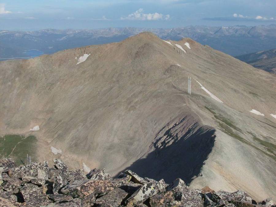
Dyer Mountain is a high Mosquito Range peak just north of Mount Sherman, above the old mining district east of Leadville. From upper Iowa Gulch it is a short, steep hike: about 3 miles round trip with around 1,775 feet of gain, all on open tundra and talus. There is no trail for most of the way, but the terrain is open and the summit is in view much of the time.
The route is Class 2. The main challenges are the altitude, the steepness of the upper slope, and loose talus near the top. The whole route is above treeline, so there is no shelter from wind, cold or lightning. Most people take 2 to 4 hours round trip.
It is a good choice for a short day or for hikers new to off-trail tundra. It can also be combined with nearby summits such as Gemini Peak and Mount Sherman along the connecting ridge.
Plan of the day
Start by
By 7 a.m. The route is short, but it is fully exposed from the car to the summit and storms can build by late morning.
Turnaround
If you are not near the summit ridge by 11 a.m., or you see storm clouds building, turn around. There is nowhere to hide on these slopes.
Crux
The steep, loose talus on the upper southeast slope just below the summit ridge.
Route-finding
Easy in clear weather: you can see the summit and the slope above the gulch. In clouds the broad slope has few features; note where you left the road so you can return to it.
Water
Little to none. Small streams in the gulch may run early in the season, but the area has a long mining history, so do not rely on them. Bring all the water you need.
From the south side of Leadville, take the Iowa Gulch road east toward the Mosquito Range. The lower road is paved and passes mining areas. It then turns to dirt and climbs up the gulch. Passenger cars can reach the lower parking areas; the last part of the road to the upper gulch at about 12,100 feet is rougher and better for high-clearance vehicles.
Much of the land in and around Iowa Gulch has old mine claims and private property. Respect closures and signs, stay out of old mine openings, and park only where it is allowed.
TundraTalus and screeRidgeExposed to lightning
The line is elevation, the band underneath is the ground, and the numbered dots match the steps below. Mileage and elevations are approximate.
1
Upper Iowa Gulch 12,100' · 0 mi
Start where the road ends in the upper gulch. Mount Sherman is the broad peak to the southeast, and Dyer is the high point on the ridge to the northeast. Look over the slope and pick your line before you start.
2
Gulch floor 12,150' · 0.1 mi
Leave the road and cross the floor of the gulch toward the base of Dyer's southeast slopes. The ground is grass, small rocks and sometimes wet spots.
Watch for: Stay clear of old mine openings and structures.
3
Lower tundra slopes 12,400' · 0.35 mi
Start up the lower slopes on grass and embedded rock. The grade is steady. Look back to see Leadville and the Sawatch Range, with Mount Massive and Mount Elbert to the west.
4
Grassy bench 12,650' · 0.55 mi
The slope eases briefly on a bench. This is a good place to catch your breath and check the weather.
5
First talus 12,900' · 0.75 mi
Grass gives way to patches of talus. Pick lines that connect grassy strips where you can; they are easier on the legs.
Watch for: Rocks can roll underfoot.
6
Southeast slopes 13,150' · 0.95 mi
The slope steepens. Aim for the ridge crest to the upper left of the summit. Take short steps and rest often.
7
Upper slope 13,400' · 1.15 mi
The talus gets looser near the top. The ridge between Dyer and Sherman comes into view to your right, with Gemini Peak between them.
Watch for: Loose talus. Do not climb directly above other people.
8
Below the ridge 13,600' · 1.3 mi
Work up the last steep section to the crest. The ground is a mix of scree and small boulders.
9
Summit ridge 13,750' · 1.42 mi
Reach the ridge. The east side drops toward the Fourmile Creek drainage. Follow the crest to the highest point.
Watch for: Strong wind on the ridge.
10
Summit 13,861' · 1.5 mi
The summit gives wide views of the Mosquito Range, Mount Sherman, the Leadville valley and the Sawatch Range to the west.
Here an unmarked path goes off to the right. Turn left to follow the road.
Coming down: Turn right to stay on the trail you came up. Don’t take the unmarked path.
2Mile 0.6 · 12,710'
Turn left
Here a road goes off straight ahead. Turn left to follow the trail.
Coming down: Turn right to stay on the trail you came up. Don’t take the road.
3Mile 1.5 · 13,860'
Turn left
Here an unmarked path goes off to the right. Turn left to follow the trail.
Coming down: Turn right to stay on the trail you came up. Don’t take the unmarked path.
Landmarks to know
The road end in upper Iowa Gulch with Mount Sherman to the southeast.
Old mine workings and scars on the slopes around the gulch.
A grassy bench partway up the southeast slopes.
The ridge linking Dyer, Gemini Peak and Mount Sherman.
Leadville and the Sawatch Range behind you to the west.
Getting down
Return the way you came. The loose talus near the top is harder going down than up, so take it slowly. Once off the steep part, head back southwest toward the road end in the gulch.
In clouds it is easy to drift too far north or south on the broad slope. Keep the gulch floor below you and check your GPS so you come down near your car and not into rougher, mined ground.
If things go wrong
Every part of this route is above treeline, so the only real safe move in a storm is to get down fast. Head straight back down the southeast slopes to the gulch and your vehicle. Avoid the east side of the ridge. If someone is hurt, keep them warm, get out of the wind if you can, and send for help. Call 911 if you have a signal. The road end is close, which helps with rescue.
3D flyover
Press play to fly the Southeast Slopes. The graph shows elevation along the way and how much you gain each mile. Open full screen.
For planning only. The line is traced from open map data, not walked in the field, and off-trail parts are drawn straight. Load it in your GPS app to see the route, but navigate with your eyes, a map and the route description.
See the trail on video
No video yet
We haven’t found a good video of this route that matches the way we describe it. The route strip, junctions and 3D flyover show the way in the meantime.
Other routes
Every way up Dyer Mountain we list, with its class.
This describes the route on a dry summer day. Snow, ice, a washed-out road or an afternoon storm can make it a very different climb. Check recent conditions the week you go and turn around when the day tells you to.