Afternoon storm risk is the line that matters. Everything else is comfort. In summer, plan to be off the ridge before the build-up starts, not as it starts. Forecast for the summit point, adjusted for its elevation · data from Open-Meteo.
Centennial 13er · Southeast Ridge
Overview
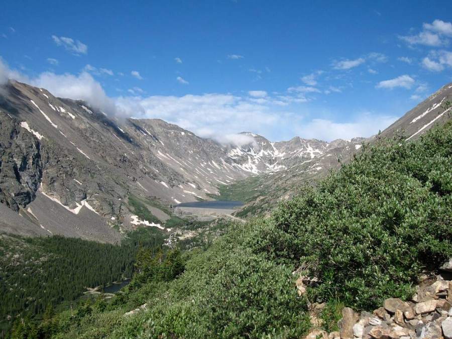
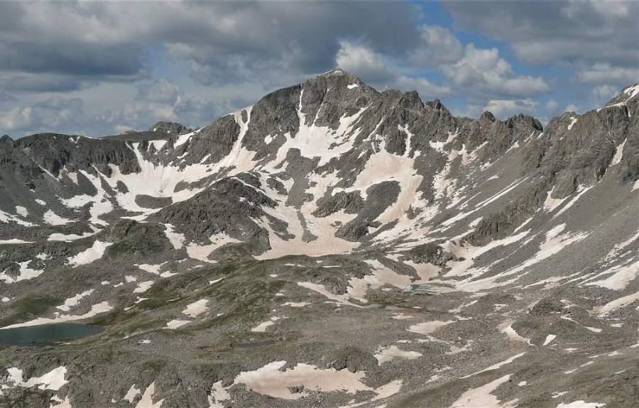
Fletcher Mountain is the high point at the south end of the Tenmile Range, just west of Quandary Peak. The route starts at the Blue Lakes dam and climbs a narrow, steep-walled valley on the west side of Quandary. It finishes on a rubbly ridge that links Fletcher to Quandary. The whole route is short, but it gains more than 2,000 feet in about two miles, so it is steep most of the way.
There is a faint trail up the lower valley, then off-trail travel on tundra, talus and rubble. There is no real exposure, and the ridge is a Class 2 walk over rock. The hard parts are the steady steepness, some loose rock, and choosing a good line out of the valley onto the high plain. It suits hikers with some off-trail experience who want a quieter peak than busy Quandary next door.
Plan on 4 to 6 hours round trip. You are above treeline the whole time, since the trailhead itself is near 11,700 feet.
Plan of the day
Start by
By 6 a.m. The trailhead is already above treeline, and there is no shelter on the route if a storm builds by late morning.
Turnaround
If you have not reached the southeast ridge by 10:30 a.m., turn around. Leave the summit by 11:30 a.m. at the latest.
Crux
Climbing out of the narrow valley onto the high plain, on steep talus and rock outcrops. The rubble on the upper ridge is loose in places but not exposed.
Route-finding
The trail up the valley is faint in spots but the valley is narrow, which keeps you on track. The key spot is near a small pond above a headwall, where you leave the valley to the left. Leaving too early or too late puts you on steeper, looser ground.
Water
The creek in the valley runs most of the summer. Above the small pond there is no water. Filter or treat it; there are old mines in the area.
From Breckenridge, drive south on Highway 9 for about 8 miles. From Hoosier Pass, drive north about 2 miles. Turn west onto Blue Lakes Road (County Road 850). This is the same turn used for Quandary Peak. Drive past the big Quandary parking lot and the private cabins. Continue about 2.3 miles from the highway to parking below the dam at the upper Blue Lake.
The road is usually fine for passenger cars. A gate is sometimes closed lower down, which adds walking. Parking near the dam is limited and fills on summer weekends. Parking rules in the Quandary area have changed in recent years, so check the current rules before you go, and do not park on the road shoulder.
TundraTalus and screeRoadRidgeScramblingExposed to lightning
The line is elevation, the band underneath is the ground, and the numbered dots match the steps below. Mileage and elevations are approximate.
1
Blue Lakes dam 11,700' · 0 mi
Walk to the northeast corner of the upper reservoir. A trail leaves the shore and climbs toward the steep valley on the west side of Quandary. Quandary's rocky west side towers on your right.
Blue Lakes and the dam where the route starts · Photo: Kevin R Foote
2
Above the reservoir 11,900' · 0.2 mi
The trail angles up to the west-northwest and gains height quickly. It passes through patches of willows. Look back for a view of the lake and dam below.
3
Talus crossing 12,000' · 0.35 mi
The trail crosses the lower edge of a talus field. Step carefully from rock to rock. On the far side, the trail bends more to the northwest.
Watch for: Rocks here can shift. Go slowly.
4
Old mining road 12,200' · 0.55 mi
Climb tundra slopes on the right side of the creek, following what is left of an old mining roadbed. You pass through more willows. The valley walls get closer and steeper.
5
Creek crossing 12,350' · 0.75 mi
The trail crosses to the left side of the stream. The creek winds through a small flat section here. Fill water now if you need it.
Watch for: Wet, slick rocks at the crossing.
6
Narrow valley 12,500' · 0.9 mi
The valley pinches in, with talus fields on both sides. The trail threads between them. Keep heading up the valley floor.
7
Headwall 12,650' · 1.05 mi
The valley ends at a steep step. The stream comes down from the right, but the trail heads up a narrow grassy gully a bit to the left. Follow that gully up.
8
Small pond 12,800' · 1.15 mi
At the top of the gully you reach a small pond. Continue northwest in the bottom of the drainage for a short way before you turn left out of it.
Watch for: Key decision point. Check weather and time.
9
Onto the high plain 13,100' · 1.4 mi
Leave the valley bottom and climb left through rock outcrops and talus. This is the steepest and roughest part. Pick the easiest breaks in the rock. You come out onto a broad, flatter plain of rock and tundra below the southeast ridge.
Watch for: Steep talus and loose rock. Keep your group together and do not climb below others.
10
Southeast ridge 13,400' · 1.7 mi
Cross the plain and climb to the ridge that links Fletcher to Quandary. Gain it west of a small bump on the ridge; there is no need to climb over that bump. Turn left and head up the ridge.
Watch for: Wind is often strong on the ridge. Add a layer.
11
Upper ridge 13,700' · 1.95 mi
Walk up the ridge on rubble and broken rock. The footing is uneven but not exposed. Stay near the crest where the rock is most stable.
12
Summit 13,943' · 2.1 mi
The rocky summit gives a close-up view of Quandary Peak and its rugged west ridge. Drift Peak is to the south and the rest of the Tenmile Range runs north.
Watch for: Start down soon if clouds are building.
Here Monte Cristo Trail goes off straight ahead. Turn right to follow Blue Lakes Trail.
Coming down: Turn left to stay on Blue Lakes Trail. Don’t take Monte Cristo Trail.
Landmarks to know
Upper Blue Lake and its dam at the trailhead
Trail leaving the northeast corner of the reservoir
Tongue of talus crossed low on the trail
Old mining roadbed on the right side of the creek
Narrow valley with talus fields on both sides
Grassy gully to the left of the stream at the headwall
Small pond at the top of the gully
Broad rock-and-tundra plain below the southeast ridge
Getting down
Go back down the ridge and across the high plain. The trickiest part is finding the same line back down into the valley. If you drop off the plain too early or too late, you can end up on steeper and looser talus or above small cliffs. Aim for the small pond at the top of the grassy gully.
From the pond, take the grassy gully down, then follow the creek back down the valley. Cross the talus tongue slowly and follow the trail back to the northeast corner of the reservoir.
If things go wrong
The small pond above the headwall is the main decision point. If weather looks bad, turn back there. From anywhere on the upper route, the fastest safe way off is back across the plain to the pond and down the valley to the lake. Do not try to drop off the ridge toward Quandary or into unknown gullies. If lightning is close, get off the ridge crest, spread out, and crouch low on your pack. If someone is hurt, keep them warm and still and send a partner down to the busy Blue Lakes area for help. Call 911 when you can reach help.
3D flyover
Press play to fly the Southeast Ridge. The graph shows elevation along the way and how much you gain each mile. Open full screen.
For planning only. The line is traced from open map data, not walked in the field, and off-trail parts are drawn straight. Load it in your GPS app to see the route, but navigate with your eyes, a map and the route description.
See the trail on video
A climb of this route filmed by Outdoor Devin. The video belongs to them and only plays when you press play.
Jump to
Other routes
Every way up Fletcher Mountain we list, with its class.
This describes the route on a dry summer day. Snow, ice, a washed-out road or an afternoon storm can make it a very different climb. Check recent conditions the week you go and turn around when the day tells you to.