Afternoon storm risk is the line that matters. Everything else is comfort. In summer, plan to be off the ridge before the build-up starts, not as it starts. Forecast for the summit point, adjusted for its elevation · data from Open-Meteo.
Centennial 13er · French, Frasco and Casco
Overview
French Mountain is a broad Sawatch peak tucked between Mount Massive and Mount Elbert, at the head of the South Halfmoon Creek basin. It is usually the first of three summits in a loop: French, then Frasco Benchmark, then Casco Peak. The full loop is about 11.75 miles round trip with about 4,600 feet of gain, starting where the 4WD road crosses Halfmoon Creek.
The climb to French is mostly an old mining road followed by a trail-less walk through open trees, willows and grassy tundra, then a rubbly ridge to a rocky top. The traverse to Casco is where the loop earns its Difficult Class 2 rating: a rough stretch of rock ribs, big blocks and boulders around Point 13,470, with optional short Class 3 moves.
This is a long day for strong hikers. Plan on 8 to 11 hours for all three summits. The ridge between the peaks stays above 13,000 feet for a long time, so weather is the main danger. Creek crossings early in the season are the other.
Plan of the day
Start by
By 5 a.m. You are above treeline from about mile 4 until you drop off Casco's southeast ridge, often five hours or more on high, open ground.
Turnaround
Be on French's summit by 9:30 a.m. and at the Frasco and Casco saddle by 11:30 a.m. If not, or if clouds are building, go down from the saddle you are nearest instead of continuing.
Crux
For French alone, it is just the long approach and the steep grass slope to the ridge. For the full loop, it is the rocky ridge between Frasco and Casco, where you cross four rock ribs and large blocks near Point 13,470.
Route-finding
The old road is easy to follow for 3.6 miles. After you leave it, there is no trail. Pick your way through open trees and around willow patches, staying on the north side of the streams. Above the willows the peaks are in plain sight.
Water
Halfmoon Creek, South Halfmoon Creek and its branches give plenty of water up to about 12,300 feet. There is none on the ridges. Filter everything.
From Leadville, drive about 3 miles southwest on US 24 to the sharp bend where the highway turns south. Turn west on Highway 300, cross the railroad tracks, and go 0.8 miles. Turn left (south) on County Road 11 and go 1.3 miles, then bear right to stay on County Road 11, which becomes Forest Road 110. Follow the graded road about 5 miles past the Halfmoon campgrounds and the Elbert Creek campground to the Mount Massive trailhead. Cars without good clearance should park here.
With good clearance, continue west about 2.1 more miles on rougher road to the junction with Forest Road 110J. Turn south and drop to Halfmoon Creek. Park near the creek; this is where the route starts. Some short 4WD vehicles drive on another mile to the South Halfmoon Creek crossing, but that crossing has stopped many vehicles, and there is almost no room to park or turn around there. Walking from Halfmoon Creek is the safer plan. There is dispersed camping near the 110J turnoff.
RoadTrail in the treesTundraScramblingTalus and screeRidgeExposed to lightning
The line is elevation, the band underneath is the ground, and the numbered dots match the steps below. Mileage and elevations are approximate.
1
Halfmoon Creek crossing 10,290' · 0 mi
Cross Halfmoon Creek on foot. There may or may not be a log to use. In early summer this crossing can be deep, fast and dangerous. Then walk south up road 110J.
Watch for: Do not cross in high water. Turn back if in doubt.
2
Road switchbacks 10,500' · 0.6 mi
The road climbs about 200 feet above Halfmoon Creek, then makes a long switchback west and back southeast through the forest before heading south again.
3
South Halfmoon Creek crossing 10,650' · 1.1 mi
The road crosses South Halfmoon Creek. Wade, rock-hop or use any old logs from a former bridge. Vehicles that could not cross are often parked here.
Watch for: Slippery rocks and cold, fast water in early season.
4
Old mining road 11,200' · 2.3 mi
Keep walking up the road into the long South Halfmoon basin. The trees open up as you go. Casco Peak's pointed top and the ridge to French begin to show at the head of the valley.
5
Last trees on the road 11,725' · 3.6 mi
At about 11,725 feet the road passes a gap in the last group of trees in the basin. Right after you cross one branch of the creek, leave the road and go west. Stay in the trees to keep out of the willows, and cross the creek's next branch.
Watch for: No trail from here; note this spot for the return.
6
Open trees above the road 11,850' · 3.8 mi
Climb west-northwest about 100 feet through some willows to another stand of trees. Stay on the north side of the next stream in the open trees to stay out of the brush.
7
Upper bench 12,300' · 4.2 mi
Follow the stream up to a flat area near 12,300 feet. A big patch of willows fills the bench. Skirt it on the north side.
Watch for: Wet, brushy ground.
8
West end of the willows 12,450' · 4.4 mi
At the west end of the willows the slope to French and Frasco steepens. You can climb straight to the French and Frasco saddle, or angle right up French's south flank to reach its southeast ridge. The flank saves repeating the ridge walk later.
9
South flank of French 13,000' · 4.7 mi
Climb the steep slope of low grass. Steer around the obvious rock outcrops and gullies. The going is steady and never exposed.
10
Southeast ridge 13,550' · 4.95 mi
Gain the southeast ridge. The ground turns to rubble, scree and small patches of tundra. Follow the ridge up and left toward the summit.
Watch for: Fully exposed to weather from here on.
11
French Mountain summit 13,942' · 5.2 mi
A rocky top with a big view of the Mount Massive massif to the north. Look south along the ridge to Frasco Benchmark and Casco Peak to plan the rest of the day.
Along the route
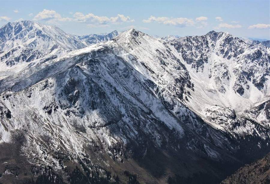
French Mountain · Photo: Jeremiah LaRocco
Landmarks to know
The old road crossing of Halfmoon Creek, then South Halfmoon Creek at about 1.1 miles.
A gap in the last stand of trees on the road near 11,725 feet, where you leave the road.
A large patch of willows on a flat bench near 12,300 feet.
Rock outcrops and gullies on French's grassy south flank.
The rubbly southeast ridge leading to French's rocky summit.
The view of Mount Massive's long ridges from the top of French.
Casco Peak's rocky point at the south end of the ridge.
Getting down
For French alone, go back down the south flank or the saddle slope to the west end of the willows, then retrace your steps to the road. Aim for the gap in the trees where you left the road; if you come down too far south, you will fight willows along the creek branches.
For the full loop, walk the ridge south over Frasco Benchmark, then drop about 600 feet to the Frasco and Casco saddle. The ground near Point 13,470 turns rocky, with four rock ribs to cross and big blocks; stay mostly on the crest to keep it at Class 2+. Climb Casco on tundra and rock to a small, blocky summit. Descend Casco's easier southeast ridge to about 13,200 feet, then leave it and head east-northeast down into the basin to rejoin the old road. Early-season snow on this slope can slide; do not glissade soft, wet snow.
If things go wrong
From French or the French and Frasco saddle, the quickest way down is east on grassy slopes back to the willows and the road. From the Frasco and Casco saddle you can also drop east into the basin. Avoid steep, rocky gullies; pick open grass. Once below about 12,300 feet you are near trees and streams. If lightning starts, get off the ridge right away rather than pushing on to the next summit. If someone is hurt, the old road is the fastest way for rescuers to reach you; get them there if you can, and call 911.
3D flyover
Press play to fly the French, Frasco and Casco. The graph shows elevation along the way and how much you gain each mile. Open full screen.
For planning only. The line is traced from open map data, not walked in the field, and off-trail parts are drawn straight. Load it in your GPS app to see the route, but navigate with your eyes, a map and the route description.
See the trail on video
A climb of this route filmed by Karl Decker Presents. The video belongs to them and only plays when you press play. This video covers French, Frasco and Casco together.
Jump to
Other routes
Every way up French Mountain we list, with its class.
French, Frasco and Cascothis routeClass 2+ 11.75 mi
This describes the route on a dry summer day. Snow, ice, a washed-out road or an afternoon storm can make it a very different climb. Check recent conditions the week you go and turn around when the day tells you to.