Afternoon storm risk is the line that matters. Everything else is comfort. In summer, plan to be off the ridge before the build-up starts, not as it starts. Forecast for the summit point, adjusted for its elevation · data from Open-Meteo.
Centennial 13er · West Ridge via Willow Creek
Overview
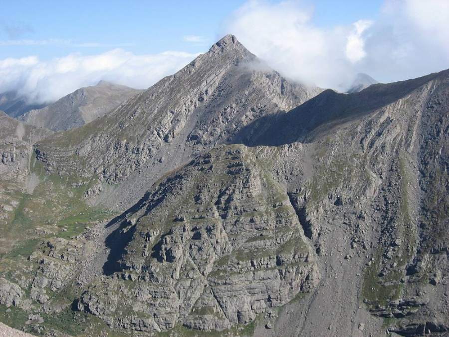
Mount Adams is a steep, pointed peak in the Sangre de Cristo Range, just north of the Crestone group. From the west side it is climbed out of the Willow Creek valley near the town of Crestone. The route follows a good trail to Willow Lake, climbs into the basin above the lake, then leaves the trail and heads up steep grass and rock to the west ridge. The ridge leads to a small summit block.
Most of the climb is Class 2 hiking on trail and steep tundra. The last part of the west ridge has some scrambling, and the summit block adds a few Class 3 moves. Some guides call the route Class 2+. The rock in this range is generally solid conglomerate, but there is loose rock and scree on the upper slopes.
The day is long: about 11.5 miles round trip and around 5,300 feet of gain. Fit hikers take 9 to 11 hours. Many people camp near Willow Lake and climb the peak in the morning. It suits hikers who have done a few Class 2 peaks and want a first taste of easy scrambling.
Plan of the day
Start by
By 5 a.m. from the trailhead, or by 6 a.m. from a camp near Willow Lake. Storms build fast over the Sangres in summer and the upper route has no shelter.
Turnaround
If you are not on the west ridge by 11 a.m., or clouds are building over the range, head back down to the lake.
Crux
The upper west ridge and summit block, where you use your hands on steep, blocky rock with some exposure.
Route-finding
The trail to Willow Lake is well used and easy to follow. Above the lake there is no trail; you pick your own line up steep slopes to the ridge. In clouds, the ridge crest can be confusing.
Water
Willow Creek along the trail, Willow Lake, and the stream in the basin above the lake. Filter everything. Nothing reliable on the ridge.
From Highway 17 in the San Luis Valley, turn east at Moffat onto the paved road to Crestone. In Crestone, head east on Galena Avenue and follow it past the edge of town. The pavement ends and a dirt road continues a short way to the Willow Creek (South Crestone) trailhead.
The dirt section is usually fine for passenger cars in dry weather. The parking area can fill on summer weekends. The trail leaves from the east end of the lot.
Trail in the treesTundraScramblingRidgeTalus and screeExposed to lightning
The line is elevation, the band underneath is the ground, and the numbered dots match the steps below. Mileage and elevations are approximate.
1
Willow Creek trailhead 8,900' · 0 mi
Start from the trailhead at the end of the road above Crestone. The trail heads east into the foothills through pine and aspen forest. Sign the register if there is one.
2
Switchbacks 9,800' · 1.2 mi
The trail climbs a long series of switchbacks up a dry, open hillside above the creek. Views open up behind you over the San Luis Valley and the Great Sand Dunes area.
Watch for: Hot and dry here in the afternoon. Carry enough water.
3
Top of switchbacks 10,700' · 2.3 mi
The trail tops out above the steep part and bends into the Willow Creek valley. It is easier walking from here as the trail enters the forest near the creek.
4
Willow Park 10,800' · 2.8 mi
Reach an open meadow along the creek. Here you get your first good look up the valley at the high peaks. The trail continues east along the north side of the valley.
5
Climb to the lake 11,300' · 3.6 mi
The trail climbs again on rocky switchbacks through the trees. You can hear the creek and waterfalls below.
6
Willow Lake 11,550' · 4 mi
Arrive at Willow Lake, set in a cirque with a tall waterfall pouring into its far end. This is a good camp area and the last easy water stop. Challenger Point and Kit Carson rise to the south, and Mount Adams is the steep peak to the north.
7
Waterfall and upper basin 11,900' · 4.3 mi
Follow the trail along the north side of the lake and up past the waterfall at the east end on rocky ledges. Above it you reach the upper basin. Leave the main trail here, which continues toward Challenger and Kit Carson.
Watch for: Wet rock near the waterfall is slick.
8
Grass slopes 12,500' · 4.7 mi
Head north up steep grass and embedded rock toward the west ridge of Adams. There is no trail. Pick the easiest line, weaving between small rock bands.
Watch for: Steep grass is slippery when wet.
9
Talus below the ridge 13,000' · 5 mi
The grass gives way to talus and scree. Work up to the ridge crest west of the summit. Take a good look at where you top out so you can find it on the way down.
Watch for: Loose rock on the upper slope.
10
West ridge 13,300' · 5.2 mi
Gain the west ridge. The summit is now to the east along a narrowing crest. The terrain is mostly broken rock and short steps at first.
11
Upper ridge scramble 13,700' · 5.55 mi
The ridge steepens and the rock gets blockier. Use your hands to climb short steps, staying near the crest where the rock is most solid. There is some exposure on both sides.
Watch for: Test holds before you pull on them.
12
Summit 13,937' · 5.75 mi
A few Class 3 moves on the small summit block put you on top. Look south to the Crestone peaks, Kit Carson and Challenger, and north along the rest of the Sangre de Cristo crest.
Along the route
Mount Adams · Photo: Xpda
Landmarks to know
The long, open switchbacks above the trailhead with views of the San Luis Valley.
Willow Park, an open meadow along the creek.
Willow Lake with a large waterfall pouring into its east end.
The upper basin above the waterfall, where you leave the trail and head north.
The west ridge crest, reached from steep grass and talus.
A small, pointed summit block at the end of the ridge.
Getting down
Return down the west ridge the way you came. The scramble is easier to downclimb if you face in on the steepest steps. Do not drop off the ridge too early. Leave the ridge at the same spot you reached it, then head south down the grass and talus toward the upper basin and the waterfall.
People sometimes drift too far east or west on the way down and end up above small cliff bands. If the ground steepens sharply, traverse to find easier terrain. Once back on the trail at the waterfall, it is a long walk out, and the switchbacks at the end are hot in the afternoon.
If things go wrong
Your quickest exit from the ridge is straight back down the route you climbed, south toward the upper basin. Do not try to descend unknown gullies off the north side. Willow Lake and the trees below it are the nearest safer ground in a storm. If someone is hurt, get them off the exposed ridge if you can do so safely, keep them warm, and send for help. Call 911 if you have a signal. Help is several hours away.
3D flyover
No 3D flyover for this peak
Past Willow Lake the last 1.5 miles leave the trail and go up grass, talus and the west ridge, with no set trail to follow. A flyover only works when there is a set trail to trace. Without one, the line would be a guess, and a guess could send you the wrong way on the mountain. Use the step-by-step route with a good map and GPS track instead.
See the trail on video
A climb of this route filmed by Backtrail Ventures. The video belongs to them and only plays when you press play.
Other routes
Every way up Mount Adams we list, with its class.
West Ridge via Willow Creekthis routeClass 3 11.5 mi
This describes the route on a dry summer day. Snow, ice, a washed-out road or an afternoon storm can make it a very different climb. Check recent conditions the week you go and turn around when the day tells you to.