Afternoon storm risk is the line that matters. Everything else is comfort. In summer, plan to be off the ridge before the build-up starts, not as it starts. Forecast for the summit point, adjusted for its elevation · data from Open-Meteo.
Centennial 13er · Southwest Ridge
Overview
Mount Meeker is the big peak just southeast of Longs Peak in Rocky Mountain National Park. Most people climb it from the Longs Peak side, but this route comes up from the south out of Wild Basin. It follows the Sandbeach Lake trail, then leaves the trail and climbs through forest and onto the long southwest ridge, a broad slope of tundra and boulders that leads to the summit ridge.
It is a quieter, less crowded way up. The hiking is mostly Class 2, but the upper ridge is a long, tiring boulder hop and the true summit is a large block with a steep drop on the north side. Stepping onto the very top takes a harder scrambling move. The off-trail section below treeline has no path, so you need to navigate.
Plan on 9 to 12 hours for the 12-mile round trip and about 5,500 feet of gain. It suits strong hikers who are comfortable off trail and on big talus. Some people camp at Sandbeach Lake with a park backcountry permit to break up the day.
Plan of the day
Start by
By 4:30 to 5 a.m. The trail to the lake takes 2 to 3 hours, and then you are above treeline for 4 or more hours on a ridge with no shelter.
Turnaround
If you are not above treeline on the ridge by 10 a.m., or storms are building over the Divide, turn around. Be off the ridge and back in the trees by 1 p.m.
Crux
The long boulder field on the upper ridge, and the final summit block, which has a steep drop on the north side.
Route-finding
The trail to Sandbeach Lake is clear. From the lake to treeline there is no trail and it is easy to wander in the forest. On the way down, it is easy to descend the wrong drainage and miss the lake.
Water
Several creeks along the trail and Sandbeach Lake itself. Filter all water. There is no water on the ridge; fill up at the lake.
From Lyons, take Highway 7 west and north toward Allenspark. Past Allenspark, turn west on the road to Wild Basin in Rocky Mountain National Park. Just before the park entrance station, the Sandbeach Lake trailhead parking area is on the right. The road is paved to this point and fine for any car.
Park entry fees apply, and the park may require an entry reservation during the busy season. Check current park rules before you go. The lot is small and fills on summer weekends. Overnight stays at Sandbeach Lake need a backcountry permit.
Trail in the treesOff-trail, no set pathTundraRidgeTalus and screeExposed to lightning
The line is elevation, the band underneath is the ground, and the numbered dots match the steps below. Mileage and elevations are approximate.
1
Sandbeach Lake trailhead 8,350' · 0 mi
Start at the Sandbeach Lake trailhead near the Wild Basin entrance. The trail climbs right away up a dry, open moraine with scattered pines.
2
Copeland Moraine 9,000' · 1.3 mi
The trail climbs steadily up the long ridge of the moraine. Look back down to Copeland Lake and the Wild Basin road. The grade is steady and the footing is good.
3
Creek crossings 9,600' · 2.6 mi
The trail heads west through thicker forest and crosses a couple of small creeks. It keeps climbing gently through lodgepole and spruce.
4
Hunters Creek area 10,000' · 3.6 mi
The trail continues west and passes near Hunters Creek, the drainage you will use to get to the ridge. Keep on the trail to the lake for now.
5
Sandbeach Lake 10,283' · 4.2 mi
Reach Sandbeach Lake, with its sandy shore. Mount Meeker and Longs Peak rise to the north. This is the last good water. Note the shape of the ridge above you before you head into the trees.
6
Off-trail forest 10,600' · 4.5 mi
Leave the trail and head north into the forest toward the Hunters Creek drainage. There is no trail. Weave around deadfall and small rock outcrops, heading uphill and north.
Watch for: Easy to get turned around in the trees. Use your GPS or compass.
7
Hunters Creek drainage 10,900' · 4.7 mi
Reach the Hunters Creek drainage and follow it uphill, staying on its east side. The trees start to thin.
8
Treeline 11,400' · 4.95 mi
Break out of the trees onto open tundra and krummholz. The southwest ridge of Meeker is the broad slope rising to the north. Pick a clear line up the ridge.
Watch for: Note where you left the trees so you can find it on the way down.
9
Southwest ridge 12,000' · 5.2 mi
Climb onto the broad ridge. It is tundra at first, with growing patches of rock. The slope is steady and long.
10
Boulder field 13,000' · 5.6 mi
The tundra ends and the ridge becomes a sea of large boulders. Hop carefully from rock to rock. Pace yourself; this part is slow.
Watch for: Some boulders rock or shift. Watch for gaps between blocks.
11
Summit ridge 13,700' · 5.9 mi
Reach the crest of the summit ridge. Longs Peak towers just to the north and the ridge drops steeply on that side. Follow the crest to the highest point.
Watch for: Steep drop-offs on the north side.
12
Summit 13,916' · 6 mi
The high point is a large block with room for one person at a time. Getting on top of it takes a harder scrambling move. The view takes in Longs Peak, Wild Basin and the plains to the east.
Watch for: The north side falls away sharply. Take your time on the summit block.
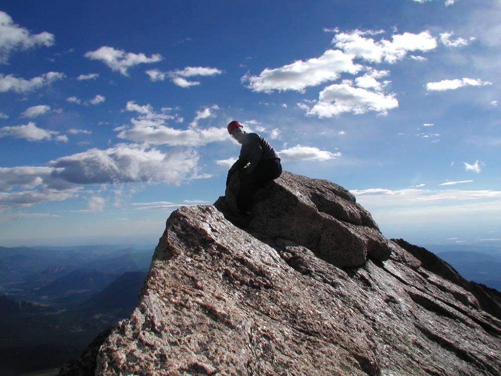
On top of Mount Meeker · Photo: Richard Masoner / Cyclelicious
Along the route
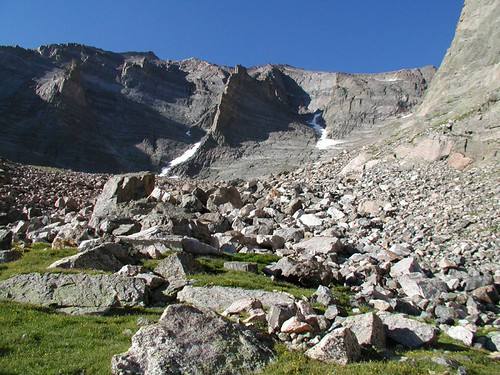
Boulders on Meeker's ridge · Photo: Richard Masoner / Cyclelicious
Landmarks to know
The open moraine above the trailhead with views of Copeland Lake.
Hunters Creek near the trail before the lake.
Sandbeach Lake, with its sandy shore and Meeker to the north.
The Hunters Creek drainage leading north into thinning trees.
Treeline and the start of the broad southwest ridge.
A large boulder field on the upper ridge.
The summit block with Longs Peak right next door.
Getting down
Go back down the southwest ridge the way you came. The boulders are tiring and more awkward going down, so go slowly. Aim for the spot where you left the trees. The ridge is broad, and in clouds it is easy to drift too far east or west.
The most common mistake is in the forest below treeline. If you head too far one way you can drop into the wrong drainage and miss Sandbeach Lake. Keep Hunters Creek close and head south toward the lake, then pick up the trail there. The long trail back down the moraine is hard on tired legs.
If things go wrong
There is no fast way off the ridge. In a storm, head straight back down the ridge toward treeline; the trees near the Hunters Creek drainage are the nearest safer ground. Do not go north toward the Longs Peak side, which is cliffed. From the lake, the trail leads 4 miles back to the trailhead. If someone is hurt, keep them warm and still, mark your position, and send for help. Call 911 if you have a signal. Park rangers handle rescues here, but it takes time.
3D flyover
No 3D flyover for this peak
The last 2 miles leave the trail at Sandbeach Lake and go off-trail through forest and boulders to the summit. A flyover only works when there is a set trail to trace. Without one, the line would be a guess, and a guess could send you the wrong way on the mountain. Use the step-by-step route with a good map and GPS track instead.
See the trail on video
No video yet
We haven’t found a good video of this route that matches the way we describe it. The route strip, junctions and 3D flyover show the way in the meantime.
Other routes
Every way up Mount Meeker we list, with its class.
This describes the route on a dry summer day. Snow, ice, a washed-out road or an afternoon storm can make it a very different climb. Check recent conditions the week you go and turn around when the day tells you to.