Afternoon storm risk is the line that matters. Everything else is comfort. In summer, plan to be off the ridge before the build-up starts, not as it starts. Forecast for the summit point, adjusted for its elevation · data from Open-Meteo.
Centennial 13er · Southeast Slopes
Overview
Mount Oklahoma sits just west of Mount Massive, above the North Halfmoon Lakes in the Mount Massive Wilderness. You follow the North Halfmoon trail up the valley, leave it below the lakes, cross a few streams through open trees and willows, then climb grassy and rocky southeast slopes to the east ridge and walk it to the top.
The route is Class 2 with no exposure. More than half the hike is on trail. The off-trail part takes some care to find the right line below the cliffs on Oklahoma's east ridge. The steepest ground is the slope up to the ridge, on tundra and small loose pebbles.
The round trip is about 7.25 miles with about 3,400 feet of gain. Plan on 5 to 7 hours. It is a good first off-trail peak for fit hikers, and far quieter than Massive next door.
Plan of the day
Start by
By 5:30 a.m. You want to reach the ridge by mid-morning and be off it before afternoon storms.
Turnaround
If you are not at the east ridge by 10 a.m., or clouds are building over Massive, turn around.
Crux
The steep slope from the upper basin to the east ridge, on low tundra and loose small rocks.
Route-finding
The trail is easy to follow up to near 12,000 feet. The tricky part is the cross-country leg from the trail to the basin below the east ridge. Stay well below the cliffs on the ridge and look for a small drainage coming down from the west.
Water
North Halfmoon Creek and several tributaries cross the route. There is no water on the upper slopes or ridge. Filter everything.
From Leadville, drive about 3 miles southwest on US 24 to where it bends sharply south. Turn right (west) on Highway 300, cross the railroad tracks and go 0.8 mile. Turn left on County Road 11 and go 1.3 miles to a fork. Bear right to stay on CR 11, which becomes Forest Road 110. Follow it about 5 miles past three campgrounds to the Mount Massive trailhead, about 7 miles from US 24.
Low-clearance cars should park at the Massive trailhead and walk the road. With more clearance, drive about 2.1 miles farther west to the turn for South Halfmoon Creek. From there, FR 110 is true 4WD, with a steep rocky hill right away. After about half a mile, the North Halfmoon Creek trailhead parking is just before the road crosses the creek. Campgrounds along Halfmoon Creek fill on summer weekends.
Trail in the treesOff-trail, no set pathTundraRidgeTalus and screeExposed to lightning
The line is elevation, the band underneath is the ground, and the numbered dots match the steps below. Mileage and elevations are approximate.
1
North Halfmoon Creek trailhead 10,560' · 0 mi
Start north on an old roadbed that soon turns into a trail. It follows North Halfmoon Creek up the valley.
2
Lower valley 10,750' · 0.6 mi
The trail climbs gently through forest and small meadows. This first stretch gains little elevation.
3
Meadows 10,950' · 1.2 mi
The trail passes more meadows with views of the peaks at the head of the valley. Mount Massive's long ridges rise on your right.
4
Massive trail junction 11,160' · 1.7 mi
A trail to Mount Massive turns off to the right. Do not take it. Stay on the North Halfmoon trail heading west.
Watch for: Easy to follow the Massive crowd by mistake.
5
Trail starts climbing 11,440' · 1.95 mi
After another stretch of forest and meadow, the trail leaves the main creek and starts gaining height.
6
Leave the trail 11,950' · 2.3 mi
Just below 12,000 feet, leave the trail and head west along an open bench with scattered trees and willows.
Watch for: Mark this spot on your GPS for the way back.
7
Small tributary 11,950' · 2.4 mi
Cross a small stream. Continue west-southwest through open trees and low willows.
8
Major tributary 11,800' · 2.55 mi
Drop about 150 feet to cross a bigger stream. Climb out the other side and follow the edge of the next stand of trees.
Watch for: Slippery rocks at the crossing.
9
Rocky area below the cliffs 11,950' · 2.7 mi
Cross a rocky area. The cliffs of Oklahoma's east ridge are well above you. Stay low and keep going southwest.
Watch for: Stay below the cliffs. Do not try to climb straight up to the ridge here.
10
Small drainage 12,300' · 2.85 mi
Watch for a small drainage coming down from the west. Climb along its south side into a flatter basin.
11
West end of the basin 12,650' · 3 mi
Head across the basin to its far west end, keeping to tundra where possible. Once you are at roughly 12,600 to 12,700 feet, swing north toward the ridge.
12
East ridge 13,150' · 3.2 mi
Climb the steepest part of the day on low tundra and loose small rocks to reach the east ridge at about 13,150 feet.
Watch for: Loose pebbles on hard ground. Take small steps.
13
Summit 13,843' · 3.6 mi
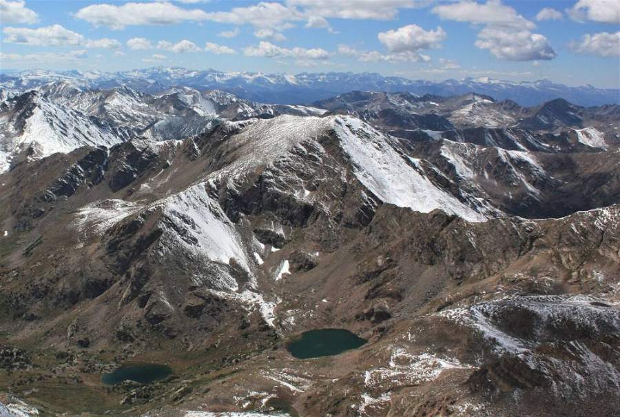
Follow the ridge northwest on patchy tundra, embedded rock and rubble to the rocky summit. Mount Massive towers to the east. The North Halfmoon Lakes sit in the basin below.
Along the route
Mount Oklahoma · Photo: Jeremiah LaRocco
Landmarks to know
Old roadbed leaving the North Halfmoon trailhead
Mount Massive trail junction (stay left, heading west)
Trail climbing away from the main creek near 11,440 feet
Open bench with trees and willows below 12,000 feet
Cliffs on Oklahoma's east ridge high above the traverse
Small drainage leading west into a flat basin
Rocky summit with Massive filling the view east
Getting down
Go back the way you came. The key is getting off the ridge at the same spot and dropping south into the basin, then finding your way back east below the cliffs. It is easy to aim too high or too low on the traverse; follow your GPS track back to where you left the trail.
The steep slope below the ridge is loose and slippery going down. Early in the season, snowfields here can offer a glissade if you carry an ice axe and the runout is clear. Once back on the trail, it is an easy walk out.
If things go wrong
The North Halfmoon trail is your safe ground. From the basin, head back east below the cliffs to the trail. If a storm hits while you are on the ridge, get down the slope into the basin as quickly as is safe. Do not try to take shortcuts down the east ridge cliffs. If someone is injured, keep them warm, mark your location, and call 911. The trail sees Massive hikers on summer weekends.
3D flyover
No 3D flyover for this peak
Just below 12,000 feet the route leaves the trail. The last 1.3 miles cross an open bench and slopes with no set trail. A flyover only works when there is a set trail to trace. Without one, the line would be a guess, and a guess could send you the wrong way on the mountain. Use the step-by-step route with a good map and GPS track instead.
See the trail on video
A climb of this route filmed by The Virtual sherpa. The video belongs to them and only plays when you press play.
Jump to
Other routes
Every way up Mount Oklahoma we list, with its class.
This describes the route on a dry summer day. Snow, ice, a washed-out road or an afternoon storm can make it a very different climb. Check recent conditions the week you go and turn around when the day tells you to.