Afternoon storm risk is the line that matters. Everything else is comfort. In summer, plan to be off the ridge before the build-up starts, not as it starts. Forecast for the summit point, adjusted for its elevation · data from Open-Meteo.
Centennial 13er · Northeast Ridge
Overview
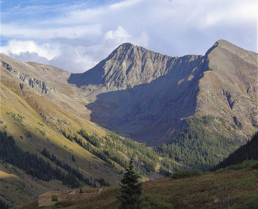
Niagara Peak is a rocky San Juan summit above the upper Animas River, near the old town site of Animas Forks. The usual route is a three-peak loop from Burns Gulch: walk a 4WD road up the gulch, climb loose talus to the saddle west of American Peak, tag American, go over Jones Mountain, and finish by following the ridge south to Niagara.
Every step above the gulch is Class 2, but the terrain is rough. Most of it is loose talus, scree and rubble, with only small patches of tundra. The ridge to American has steep cliffs on its north side, and the climb to Jones has a rocky step that some call Class 2+. The loop stays above 13,000 feet for a long time.
The round trip is about 9.6 miles with about 4,145 feet of gain from the bottom of Burns Gulch. With a capable 4WD you can drive about 2 miles up the gulch and save over 900 feet. Plan on 7 to 9 hours on foot. It suits hikers who are steady on loose rock.
Plan of the day
Start by
By 5 a.m. You cross three summits on a high ridge, and San Juan storms often build before noon.
Turnaround
If you are not at the saddle west of American Peak by 9 a.m., cut the day short. If you are not on Jones by 11 a.m., skip Niagara and head down.
Crux
The steep, loose scree and talus climb from the small lake to the saddle west of American, and the rocky step at the start of Jones's northeast ridge.
Route-finding
The road is easy. Above the road fork, head into the northeast fork of the gulch, keeping left (west) of a big rock glacier. On the ridges, the route is clear in good weather, but leaving Jones in clouds it is easy to follow its southeast ridge by mistake instead of heading toward Niagara.
Water
Burns Gulch creek runs beside the road. A very small lake sits near 12,520 feet. Nothing on the ridges. Filter everything; there is old mining in the area.
From Silverton, drive east through town and bear right onto County Road 2 where the paved road splits, just past the courthouse. Follow it about 4.2 miles to Howardsville; the pavement ends after about 2 miles. Continue about 4.3 miles to the old Eureka town site, where the road crosses the Animas River and climbs a steeper shelf. Go about 3.5 more miles to the turnoff for Burns Gulch and Grouse Gulch, where the main road crosses back to the east side of the river on a bridge.
Most crossover SUVs can reach the parking near the bridge. Without a high-clearance 4WD, park here. The Burns Gulch road is a narrow, rocky single lane with shelf sections where passing is hard. With a capable 4WD you can drive to a fork at about 11,680 feet. There are no forest service campgrounds along this road, but dispersed sites are common; watch for private land.
RoadTundraTalus and screeRidgeExposed to lightning
The line is elevation, the band underneath is the ground, and the numbered dots match the steps below. Mileage and elevations are approximate.
1
Burns Gulch trailhead 10,790' · 0 mi
Park near the bridge over the Animas. Walk south along the east side of the river on a spur road for about 0.2 mile to meet the Burns Gulch road.
2
Burns Gulch road 10,900' · 0.2 mi
Turn onto the Burns Gulch road. It climbs southeast in an ascending traverse up the side of the gulch.
Watch for: Watch for vehicles on the narrow shelf road.
3
Shelf road 11,250' · 1 mi
The road runs along a narrow shelf, then continues up the gulch. Old switchbacks shown on some maps are now bypassed.
4
Road fork 11,680' · 2 mi
Reach a main fork in the road at about 11,680 feet. 4WD drivers park here. Head into the northeast fork of the gulch on grassy ground.
5
Rock glacier 12,100' · 2.4 mi
Follow old roadbed for part of the way. Stay left (west) of the tongue of a large rock glacier.
6
Small lake 12,520' · 2.8 mi
A very small lake sits at about 12,520 feet. Continue east past it on tundra for a short way.
Watch for: Last water of the day.
7
Saddle west of American Peak 13,340' · 3.4 mi
Climb toward the saddle between Jones and American's west ridge. The slope steepens and the rock turns to loose scree and dirt. A rough climbers' path may help.
Watch for: Loose scree. Space out so no one is below another person.
8
American Peak ridge 13,600' · 3.8 mi
From the saddle, head east along American's west ridge. The north side drops off in cliffs; stay on the south side of the crest. Contour near 13,600 feet to skip the ups and downs over three bumps.
Watch for: Cliffs on the north side of the ridge.
9
American Peak 13,806' · 4.1 mi
Reach American's summit. Take a look at the ridge to Jones to the west, then head back carefully along the same line.
10
Back at the saddle 13,340' · 4.6 mi
Return west over the talus to the saddle. A little tundra on the way down gives your feet a break.
11
Ridge step 13,500' · 4.8 mi
A rocky step blocks the start of Jones's northeast ridge. It is the hardest part of this climb. A use path helps.
Watch for: Class 2+ moves on loose rock. Take your time.
12
Notch above a couloir 13,700' · 5 mi
The ridge levels out for a while, then passes a notch at the top of a big, steep couloir that drops to the north. Beyond it, the final climb steepens.
Watch for: Stay back from the edge of the couloir.
13
Jones Mountain 13,860' · 5.3 mi
Reach the summit of Jones. Niagara is the obvious peak to the south. Head south, then south-southwest down the ridge.
Watch for: Do not follow Jones's southeast ridge by mistake, especially in clouds.
14
Jones-Niagara saddle 13,220' · 5.8 mi
Descend about 640 feet to the saddle, with a few patches of low tundra on the way. Past it, the rock returns.
15
Summit 13,816' · 6.2 mi
Climb about 600 feet on scree, rubble and talus to the top of Niagara. Crown Mountain sits nearby, just a short rise from the saddle beyond.
Here a road goes off straight ahead; Burns Gulch Road goes off to the right. Keep right to follow the road.
Coming down: Keep right to stay on the trail you came up. Don’t take the road or Burns Gulch Road.
2Mile 0.8 · 11,160'
Keep left to stay on Burns Gulch Road
Here a road goes off to the right. Keep left to follow Burns Gulch Road.
Coming down: Keep right to stay on Burns Gulch Road. Don’t take the road.
3Mile 4.6 · 13,340'
Keep right to stay on Burns Gulch Road
Here an unmarked path goes off to the right; a road goes off to the left. Keep right to follow Burns Gulch Road.
Coming down: Keep left to stay on Burns Gulch Road. Don’t take the unmarked path or the road.
4Mile 6.2 · 13,820'
Keep right
Here an unmarked path goes off to the left. Keep right to follow the trail.
Coming down: Keep left to stay on the trail you came up. Don’t take the unmarked path.
Landmarks to know
Bridge over the Animas River at the Burns Gulch turnoff
Narrow shelf road climbing Burns Gulch
Road fork at about 11,680 feet
Large rock glacier (keep it on your right)
Tiny lake near 12,520 feet
Saddle west of American Peak
Notch at the top of a big couloir on Jones's ridge
Niagara, the obvious peak south of Jones
Getting down
From Niagara, you can return north over the saddle and back up Jones, then retrace your route to the saddle west of American and down past the small lake. Some parties instead drop west from the Jones-Niagara saddle into upper Burns Gulch. Only do this if you can see from above that the slope is easy grass and scree all the way down, and rejoin the road near the fork.
Leaving Jones in clouds is where people go wrong. Take a bearing before you start down. The loose scree below the saddle west of American is slippery going down; move one at a time. On the road, watch for vehicles on the narrow shelf.
If things go wrong
The saddle west of American Peak is the key escape point: from there, the scree slope leads back to the lake and the road. If weather turns before Jones, return to that saddle and descend. Once on Jones or beyond, the quickest way off may be down into Burns Gulch from the Jones-Niagara saddle, but only if the slope looks safe. If someone is injured, keep them warm, mark your location, and call 911. Jeep traffic in the area on summer days may help get word out.
3D flyover
Press play to fly the Northeast Ridge. The graph shows elevation along the way and how much you gain each mile. Open full screen.
For planning only. The line is traced from open map data, not walked in the field, and off-trail parts are drawn straight. Load it in your GPS app to see the route, but navigate with your eyes, a map and the route description.
See the trail on video
A climb of this route filmed by Rocky Mountain Summits. The video belongs to them and only plays when you press play. This video covers Jones Mountain and Niagara Peak together.
Other routes
Every way up Niagara Peak we list, with its class.
This describes the route on a dry summer day. Snow, ice, a washed-out road or an afternoon storm can make it a very different climb. Check recent conditions the week you go and turn around when the day tells you to.