Afternoon storm risk is the line that matters. Everything else is comfort. In summer, plan to be off the ridge before the build-up starts, not as it starts. Forecast for the summit point, adjusted for its elevation · data from Open-Meteo.
Centennial 13er · East Slopes
Overview
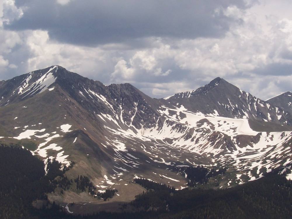
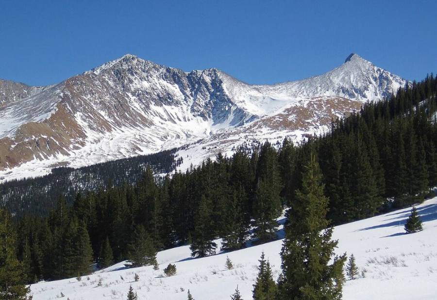
Pacific Peak is a steep, pointed summit in the Tenmile Range southwest of Breckenridge. Its summit ridge has a deep notch cut into it that you can spot from far away. This route climbs the popular Mohawk Lakes trail, then leaves the crowds and goes off-trail through a chain of high benches and small lakes to Pacific Tarn. The tarn sits above 13,400 feet and is one of the highest named lakes in North America. From there you climb steep talus to the summit ridge.
The first half is a busy, well-built trail with waterfalls, old mine ruins and two blue lakes. The second half is rough, trailless talus and scree. The last part, near the notch, is steep and loose, and a slip there could be serious. This route suits hikers who are comfortable on Class 2 talus and who can find their own way above the lakes.
The round trip is about 11 miles. Plan on 8 to 10 hours for most parties. You will spend about 4 hours above treeline, much of it far from any trail, so an early start matters.
Plan of the day
Start by
By 5 a.m. The trail to the lakes takes 2 to 3 hours, and you want to be off the upper talus before storms build, often by late morning.
Turnaround
If you have not reached Pacific Tarn by 10:30 a.m., turn around. Start down from the summit by 11:30 a.m. at the latest, sooner if clouds build.
Crux
The steep, loose summit ridge near the notch. You will need care with footing and may use your hands to get across it.
Route-finding
Easy to the upper Mohawk Lake on a clear trail. Above that there is no real trail, only faint paths and a few cairns. People lose time picking lines through the rock benches above the upper lake. In fog it is easy to lose the way to the tarn.
Water
Spruce Creek and the Mohawk Lakes have plenty of water. Small lakes and streams continue above the upper lake. Pacific Tarn is the last water. Filter or treat everything; there are old mines up the valley.
From the center of Breckenridge, drive south on Highway 9 for about 2.5 miles. Turn right (west) onto Spruce Creek Road. It passes through a neighborhood of homes and climbs about 1.2 miles to the lower Spruce Creek trailhead. Passenger cars can reach this trailhead.
The road continues past the lower trailhead as a rough, rocky four-wheel-drive track toward an upper parking area. Only high-clearance 4WD vehicles should try it, and parking at the top is small. This description starts at the lower trailhead. The lot fills early on summer weekends, so arrive before dawn. Do not park along the residential road.
RoadTrail in the treesTundraTalus and screeRidgeExposed to lightning
The line is elevation, the band underneath is the ground, and the numbered dots match the steps below. Mileage and elevations are approximate.
1
Spruce Creek trailhead 10,400' · 0 mi
Start on the Spruce Creek trail at the west side of the lot. The trail climbs gently through thick spruce and fir forest. It is wide, well used and easy to follow.
2
Wheeler Trail crossing 10,900' · 1 mi
The trail crosses the Wheeler Trail and then meets the rough 4WD road near the upper parking area. Keep heading west on the trail toward Mohawk Lakes. Stay on the main path at each junction.
Watch for: Several trails cross here. Stay on the route to Mohawk Lakes.
3
Mayflower Lakes spur 11,000' · 1.3 mi
A side trail branches off to Mayflower Lakes. Stay on the main trail. The forest starts to thin and you hear the creek getting louder ahead.
4
Continental Falls 11,300' · 1.8 mi
The trail climbs steeply next to a long series of cascades. Look for old mining ruins, including a wooden cabin and rusted tramway parts. The trail gets rockier here and has some steep steps.
Watch for: The rocks near the falls can be wet and slick. Stay back from the edge of the water.
5
Lower Mohawk Lake 11,800' · 2.2 mi
The trail tops out at the lower lake, set in a bowl below rocky cliffs. Most day hikers stop here. Keep following the trail around and up toward the upper lake.
6
Upper Mohawk Lake 12,100' · 2.5 mi
The upper lake sits above treeline in a bigger, rockier basin. Pacific Peak rises to the west. The trail ends here. From now on you are on your own on tundra, talus and rock benches.
Watch for: Last good place to rest and filter water before the rough ground.
7
Benches above the upper lake 12,500' · 3.2 mi
Head west up the drainage. You climb a series of steps: short rock bands, patches of tundra, and small ponds. Look for the easiest breaks in each band. Faint paths and a few cairns may help, but they come and go.
Watch for: Early season snow can cover these benches. It can be hard and icy in the morning.
8
Upper basin 12,900' · 3.8 mi
The terrain turns mostly to talus. Pacific Peak is ahead and to the right, with its notched summit ridge in view. Keep climbing west toward the high saddle area south of Pacific, where the tarn sits.
Watch for: Talus here can shift. Step on the flattest, biggest rocks.
9
Pacific Tarn 13,400' · 4.5 mi
You reach a small, cold lake in a rocky bowl, often with ice on it well into summer. This is a good spot to check the weather and the time. Look up and to the north to plan your line up the slopes to the summit ridge.
Watch for: Turnaround check. If it is past 10:30 a.m. or clouds are building, go down from here.
10
East slopes 13,650' · 4.9 mi
Leave the tarn and climb north up steep talus and scree toward the ridge. Pick the most stable rock you can. Zig-zag to ease the grade and to keep out of the fall line of people above you.
Watch for: Rockfall. Do not climb directly below another party.
11
The notch 13,850' · 5.3 mi
Near the top the ridge is split by a deep notch. The rock here is broken and loose. Move slowly, test each hold, and cross it carefully. Take your time and keep your group close.
Watch for: This is the crux. A slip or loose block here could be serious.
12
Summit 13,965' · 5.5 mi
A short scramble past the notch brings you to the small, rocky top. You can see Crystal Peak close by to the south and Quandary to the southeast. Start down soon; the loose ground is harder to descend than to climb.
Watch for: Do not stay long if weather is building.
Along the route
Crystal and Pacific Peaks · Photo: foto3116Crystal and Pacific peaks · Photo: John Holm
Landmarks to know
Wide Spruce Creek trail through thick forest
Wheeler Trail crossing and the rough 4WD road near the upper parking area
Continental Falls with old wooden cabin and rusted mining tram parts
Lower and upper Mohawk Lakes, the upper one above treeline
Rock benches and small ponds west of the upper lake
Pacific Peak's notched summit ridge in view from the upper basin
Pacific Tarn, a small icy lake in a rocky bowl south of the summit
The deep notch on the summit ridge just before the top
Getting down
Return the same way. Cross the notch again with care and go slowly on the steep talus back down to Pacific Tarn. Loose rock is easier to knock down when descending, so watch your feet and stay out of the line of anyone below.
The most common problem is route-finding through the benches below the tarn. It is easy to drift too far north or south and end up above small cliffs. Aim back east toward the upper Mohawk Lake, and look for the breaks you used on the way up. Once you reach the upper lake, pick up the trail and follow it down past the falls. The steep rocky steps by the falls are slick when wet, so take them slowly.
If things go wrong
Pacific Tarn is the last good decision point. If weather looks bad or someone is tired, turn around there. Below the tarn, the benches lead back to the upper Mohawk Lake and the trail, which is the fastest safe way out. Do not try to shortcut down unknown gullies off the ridge. If lightning is close, get off the ridge and away from high points, spread out, and wait it out low on the talus. If someone is hurt, keep them warm, mark your location, and send someone down to the lakes, where the busy trail makes it more likely to find help. Call 911 when you can reach help.
3D flyover
No 3D flyover for this peak
The trail ends at Upper Mohawk Lake. The last 3 miles are climbers' paths, talus and the ridge with no set trail. A flyover only works when there is a set trail to trace. Without one, the line would be a guess, and a guess could send you the wrong way on the mountain. Use the step-by-step route with a good map and GPS track instead.
See the trail on video
No video yet
We haven’t found a good video of this route that matches the way we describe it. The route strip, junctions and 3D flyover show the way in the meantime.
Other routes
Every way up Pacific Peak we list, with its class.
This describes the route on a dry summer day. Snow, ice, a washed-out road or an afternoon storm can make it a very different climb. Check recent conditions the week you go and turn around when the day tells you to.