Afternoon storm risk is the line that matters. Everything else is comfort. In summer, plan to be off the ridge before the build-up starts, not as it starts. Forecast for the summit point, adjusted for its elevation · data from Open-Meteo.
Centennial 13er · Northwest Couloir
Overview
Pigeon Peak is the steep, pointed tower you can see from the train as it runs along the Animas River. Its summit sits about a mile above the river. There is no road to it. You ride the Durango and Silverton train to the Needleton stop, then hike a rough, hard-to-follow trail up into a high basin on the northwest side of the peak. Almost everyone camps there and climbs the peak the next morning.
The climb from camp is short but steep. You go up a long couloir that starts as grass and turns to rock, then scramble on big blocky granite near the top. The last few hundred feet are Class 3, with one short, steep slot that some people rate harder. The approach is the real test: the trail is steep, faint in places, and the last part to the basin is a bushwhack through timber, deadfall and boulders.
This trip suits strong backpackers who are comfortable finding their own way off trail. Plan on a full day to reach camp, and about 1.5 to 3 hours from camp to the summit. The train schedule limits your time, so build in a spare day. Help is far away here.
Plan of the day
Start by
Leave camp by 5 or 5:30 a.m. You are on open, steep terrain the whole way from camp, and the couloir is a bad place to be when afternoon storms hit.
Turnaround
If you are not at the top of the couloir, where the blocky granite starts, by 10 a.m., or if clouds are building fast, turn around.
Crux
The upper Class 3 scramble on stacked granite blocks just off the north ridge, including a short, steep slot about 15 feet tall that some climbers rate as Class 4.
Route-finding
Hard on the approach. The Ruby Creek trail start is hard to find, and the side route to the northwest basin fades into scattered cairns and bushwhacking. From camp the couloir is obvious.
Water
Pigeon Creek, North Pigeon Creek and the streams in the basin near camp. Filter all water. There is no reliable water in the couloir once you leave camp.
There is no road access. Take the Durango and Silverton Narrow Gauge Railroad and ask to be dropped at the Needleton stop. Train policies on where you can board and get off have changed over the years, so check with the railroad before you plan the trip. Know the pickup time for your return and do not miss it.
From the Needleton stop, cross the Animas River on the footbridge to the east side. The route starts here at about 8,235 feet. There are cabins on private land near the bridge, so stay on the trail until you are past them.
Needleton (Durango & Silverton train). Road conditions near the trailhead change after storms. Check your clearance and have a backup plan for a lower lot.
Trail in the treesOff-trail, no set pathTalus and screeSnow or couloirScramblingExposed to lightning
The line is elevation, the band underneath is the ground, and the numbered dots match the steps below. Mileage and elevations are approximate.
1
Needleton footbridge 8,235' · 0 mi
Get off the train and cross the Animas on the sturdy footbridge. On the east side, turn left (north) on the trail that runs past the cabins and along the river. Stay on the trail near the private cabins.
2
Pigeon Creek crossing 8,250' · 0.4 mi
Follow the riverside trail north to Pigeon Creek. This crossing is usually easy. Keep going north-northeast into a wide, open grassy meadow.
Watch for: Do not confuse this with North Pigeon Creek higher up.
3
Campers Meadow log 8,300' · 0.6 mi
Near the north part of the meadow, look for a log across the trail with a piece cut out so the trail can pass. At this spot, look right (east) for a faint path climbing a dirt bank into the trees. That is the start of the Ruby Creek trail. A different faint path angles left toward Noname Creek; do not take it.
Watch for: The start is easy to miss. If you reach the end of the meadow, go back and look again.
4
Upper meadow 8,400' · 0.8 mi
Above the bank the path enters a smaller meadow and fades. Find where it leaves the meadow heading south, down-valley. It feels wrong, but it is correct. The path then winds through trees and bends east toward the base of the mountain.
Watch for: Easy to lose the path in this meadow.
5
Old mine, constructed trail 8,500' · 1.1 mi
At the base of the slope you reach an old mine site. From here a built trail angles up the hillside at a steep grade. The climbing starts in earnest.
6
North Pigeon Creek crossing 9,500' · 1.7 mi
The trail climbs very steeply, at times so steep you may grab aspen trunks to pull up. It rounds a small ridge and crosses North Pigeon Creek near 9,500 feet. Just past the crossing the trail forks. Take the steeper, less used branch heading northeast above the creek.
Watch for: Steep, loose dirt is slick when wet.
7
Junction at 9,800 feet 9,800' · 1.9 mi
About 0.15 mile past the fork, near 9,800 feet, the trail splits again. The left branch continues to Ruby Creek. Take the right branch, which follows a small ridge up the North Pigeon drainage toward the northwest basin.
Watch for: This junction is faint. Check your map and GPS here.
8
Cairned bushwhack 10,400' · 2.3 mi
The path quickly fades to a few cairns and then to a Class 2 bushwhack. Keep heading southeast above the creek. You will find short bits of path that fade out again. Expect deadfall, rock ledges and steep forest.
Watch for: It is easy to drift off line. Keep the creek below you on your right and keep heading southeast.
9
Out of the trees 11,000' · 2.7 mi
Around 11,000 feet the timber opens up and the going gets a little easier. You can now see the big northwest face of Pigeon ahead and the basin below it.
10
Boulder field 11,400' · 3 mi
Keep heading southeast. Cross a boulder field on large, stable blocks. The flat meadow of the basin comes into view ahead.
Watch for: Boulders can shift. Test footing with a heavy pack.
11
Basin camp 11,740' · 3.25 mi
The large, flat meadow at the northwest foot of Pigeon has lots of room for tents. The east end, just before the ground starts to rise, has large boulders for shelter. Willows and water are close by. Look up and you can see the big couloir sweeping down from the summit.
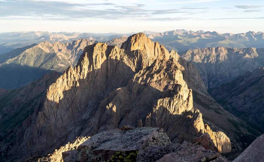
Turret and Pigeon peaks · Photo: Kylie Stewart
12
Lower couloir 12,300' · 3.5 mi
From camp, head up into the big couloir that curves down from the summit. The lower part is steep tundra. The middle of the gully is rockier; the grassy edges on the left have rock outcrops to work around.
Watch for: Steep grass is very slick when wet or frosty.
13
Center gully 13,000' · 3.8 mi
As you get closer to the north ridge, bear right (south). The terrain pushes you into the center of the gully on rock, gravel and talus. Early in the season this area may hold snow.
Watch for: Loose rock in the gully. Do not climb directly below another party.
14
Granite blocks 13,600' · 4.05 mi
Just below and off the north ridge, the rock turns into large, broken granite blocks with gravel ledges and cracks between them. The blocks stack on each other and the climbing becomes Class 3. Pick your way up through the cracks and ledges.
Watch for: Exposure is moderate in short sections.
15
Short slot 13,850' · 4.15 mi
Higher up there is a steep, chimney-like slot about 15 feet tall. Some climbers call it Class 4. Use good hand and foot holds and move carefully. Above it, the scrambling eases back to Class 3.
Watch for: Hard to downclimb. Note your line on the way up.
16
Summit 13,977' · 4.25 mi
Scramble to the cracked summit block. The north point is the highest. You can look straight down to the Animas River and across to the peaks of Ruby Creek and Chicago Basin.
Along the route
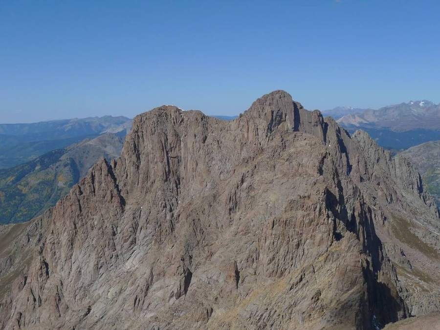
Turret and Pigeon · Photo: Jeremiah LaRocco
Landmarks to know
The footbridge over the Animas at Needleton.
The log with a cut-out section in Campers Meadow, with a faint path climbing a dirt bank to the east.
An old mine at the base of the slope where a built trail starts climbing.
The North Pigeon Creek crossing near 9,500 feet and the fork just beyond it.
A boulder field just before the flat meadow of the northwest basin.
The big curving couloir that drops from the summit right to the camp meadow.
Large, stacked granite blocks just off the north ridge near the top.
A cracked summit block; the north point is the true top.
Getting down
Go back down the way you came. Downclimb the short slot and the granite blocks with care, facing in where needed. Once back in the couloir, it is easy to drift too far left or right; aim for the center line that leads straight down to the camp meadow. The steep grass in the lower couloir is slippery, especially when wet, so take small steps.
On the hike out from camp, the bushwhack is easy to get wrong going downhill. Keep the creek on your left as you descend northwest, and look for cairns to find the path near 9,800 feet. The steep trail down to the old mine is loose and hard on knees. Leave plenty of time to reach Needleton before your train.
If things go wrong
Your safest ground is the camp meadow at the foot of the couloir. If weather turns while you are in the couloir, head straight down its center to camp. Do not wait out a storm on the upper blocks. This area is very remote and there is no easy exit; the only way out is the long, steep trail back to Needleton and a train that runs on a fixed schedule. If someone is hurt, stabilize them, keep them warm, and send for help or use a satellite messenger; call 911 if you can get a signal. Rescue here can take a long time.
3D flyover
No 3D flyover for this peak
Past the first half mile out of Needleton, the Pigeon Creek approach has no mapped trail, only cairns, bushwhacking and a couloir. A flyover only works when there is a set trail to trace. Without one, the line would be a guess, and a guess could send you the wrong way on the mountain. Use the step-by-step route with a good map and GPS track instead.
See the trail on video
No video yet
We haven’t found a good video of this route that matches the way we describe it. The route strip, junctions and 3D flyover show the way in the meantime.
This describes the route on a dry summer day. Snow, ice, a washed-out road or an afternoon storm can make it a very different climb. Check recent conditions the week you go and turn around when the day tells you to.