Afternoon storm risk is the line that matters. Everything else is comfort. In summer, plan to be off the ridge before the build-up starts, not as it starts. Forecast for the summit point, adjusted for its elevation · data from Open-Meteo.
Centennial 13er · Southeast Ridge
Overview
Vermilion Peak is the highest summit in the San Miguel Mountains, a cluster of dark red, rotten-looking peaks south of Telluride. This route starts at the Lake Hope trailhead, follows a popular trail past Lake Hope to a high pass, then works north along a rocky ridge over two smaller summits to the saddles below Vermilion. A use trail then climbs Vermilion's southeast ridge to the top. The round trip is about 9.15 miles with about 4,450 feet of gain.
Above the pass there is almost no tundra. The ridge is made of large, broken, loose blocks that tip and slide when you step on them. The final climb on Vermilion has some rock towers to skirt, then a steep, dirty gully and a short, narrow summit ridge. It is rated Difficult Class 2 with brief exposure near the top.
This route suits hikers who are steady on loose talus and do not mind a slow, careful pace. Plan on 7 to 10 hours. Rockfall, both from your own feet and from other parties, is the main danger, along with afternoon storms on a ridge that is slow to escape.
Plan of the day
Start by
By 5 a.m. It takes about an hour to reach the lake, and the rest of the day is on exposed, slow terrain above 12,400 feet.
Turnaround
If you are not at the Fuller and Vermilion saddle by 10:30 a.m., or clouds are building, turn around. The Beattie and Fuller saddle is the easiest place to head down.
Crux
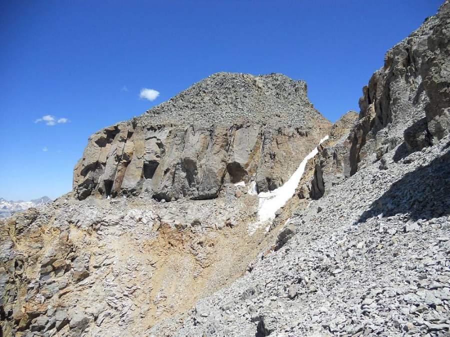
The upper southeast ridge of Vermilion: a trail skirts some crumbling towers, then a steep, loose gully leads to a false summit and a short, narrow ridge to the true top.
Route-finding
The trail is clear to the pass above Lake Hope. The ridge beyond is obvious, but the loose rock makes it easy to wander. Between Beattie and Vermilion, look for a use trail that angles left from just past the Beattie and Fuller saddle across to the Fuller and Vermilion saddle. On Vermilion, the trail stays mostly on the south (left) side of the crest.
Water
Streams along the lower trail and Lake Hope itself. There is no water on the ridge. Fill up and filter at or below the lake.
From Telluride, drive west on Highway 145 about 3 miles to the junction, then turn left to stay on Highway 145 heading south toward Lizard Head Pass. After about 10 miles, turn left onto County Road 63A toward Trout Lake. Go about 1.7 miles to Forest Road 627 and stay left on it. The trailhead is roughly 2.5 to 3 miles up this road, at a sharp switchback.
The last couple of miles are rough dirt, and a high-clearance vehicle is recommended. Land around Trout Lake and along the road is partly private, so camp only where it is clearly allowed. There is a pullout a little below the trailhead. Forest Service campgrounds are near Lizard Head Pass.
Trail in the treesTundraRidgeTalus and screeScramblingExposed to lightning
The line is elevation, the band underneath is the ground, and the numbered dots match the steps below. Mileage and elevations are approximate.
1
Lake Hope trailhead 10,745' · 0 mi
Start on the Hope Lake Trail. It heads east at first and gains a little to cross Poverty Gulch, then drops slightly before it starts to climb in earnest.
2
Switchbacks through forest 11,300' · 0.8 mi
The trail climbs steep switchbacks through spruce and fir, then across rock slides and wildflower meadows. Gaps in the trees show Trout Lake below. The dark red bulk of Vermilion rises to the east.
3
Alpine meadows 11,800' · 1.5 mi
The trees end and the trail climbs grassy slopes. It tops a grassy rise between two rocky hills.
4
Lake Hope 11,900' · 2 mi
Lake Hope comes into view, a clear blue lake in a rocky bowl. Stay on the trail along the east shore. This is the last water.
Watch for: Fill and filter water here.
5
Pass above Lake Hope 12,445' · 2.7 mi
The trail climbs to a pass at about 12,445 feet. The trail continues down the far side toward South Mineral Creek; do not follow it. Turn left (north-northeast) and climb onto the ridge.
Watch for: Do not drop down the far side of the pass.
6
Ridge to UN 13,302 13,000' · 3 mi
The first 150 feet up the ridge are easy. Then the ridge turns to large, broken rock that shifts under your feet. It steepens and eases near 13,220 feet. Stay mostly on the crest.
Watch for: Loose blocks roll easily; do not climb below others.
7
UN 13,302 summit 13,302' · 3.3 mi
The high point is at the far northeast end of the summit ridge. There is one notch with brief exposure and loose rock. From here you can see Beattie, Fuller and Vermilion lined up to the north.
Watch for: Take care at the notch.
8
Beattie Peak 13,342' · 3.8 mi
Drop to a saddle, then follow the same blocky ridge northeast over some small rock outcrops to Beattie Peak. Expect about half an hour of slow, careful walking.
9
Beattie and Fuller saddle 13,100' · 4 mi
Head north down to the saddle between Beattie and Fuller. Just past it, pick up a use trail that angles left across the slope toward the Fuller and Vermilion saddle, skipping Fuller's summit.
Watch for: Easiest bail point: a tundra slope drops southwest to the Lake Hope trail.
10
Fuller and Vermilion saddle 13,300' · 4.3 mi
Reach the saddle. Vermilion's southeast ridge rises to the northwest, all broken red and gray rock with no grass. Follow the trail that stays mostly on the south (left) side of the crest.
Watch for: Last good place to decide on the weather.
11
Towers on the ridge 13,650' · 4.45 mi
About halfway up, the trail gets harder to follow around a rock tower. Look around for the path before scrambling. Stay off the crumbling crest.
Watch for: Crumbly pinnacles; do not pull on loose blocks.
Vermilion Peak · Photo: John Sowell
12
Summit gully 13,800' · 4.55 mi
A steep, dirty gully leads to a false summit. Use your hands for balance and test every hold. Keep your group close so any loose rock cannot build speed.
Watch for: Steep, loose scrambling; helmet on.
13
Vermilion Peak summit 13,909' · 4.6 mi
From the false summit, a short, narrow bit of ridge leads to the true high point. Golden Horn is just north, and Lake Hope sits far below to the southwest.
Watch for: Brief exposure on the final ridge.
Along the route
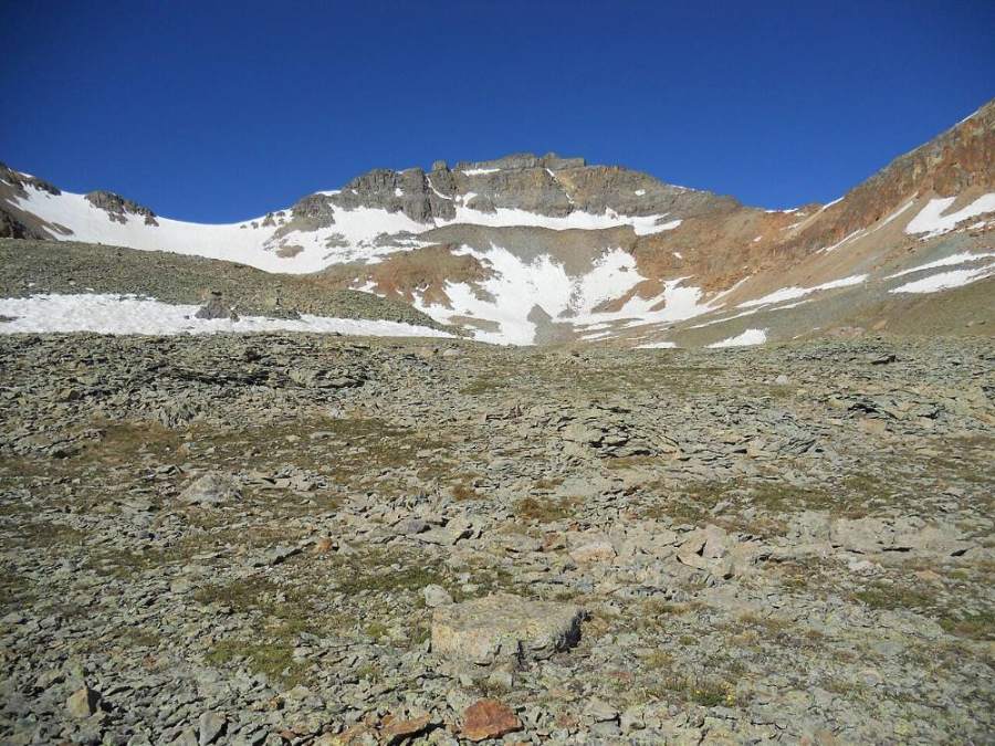
Vermilion Peak from the ridge · Photo: John Sowell
Landmarks to know
Poverty Gulch crossing near the start.
Views of Trout Lake through the trees on the switchbacks.
Lake Hope in its rocky bowl.
The pass at about 12,445 feet above the east shore of the lake.
The row of red, blocky summits: UN 13,302, Beattie, Fuller and Vermilion.
A use trail angling left past the Beattie and Fuller saddle.
Crumbly rock towers midway up Vermilion's southeast ridge.
A steep gully and false summit just below the top.
Getting down
Go back down the southeast ridge slowly. The steep gully below the false summit is the most likely place to slip or knock rocks down; face in if you need to, and wait for anyone below you to move out of the fall line. Follow the trail on the south side of the crest back to the Fuller and Vermilion saddle, then take the use trail back to the Beattie and Fuller saddle.
From the Beattie and Fuller saddle, you do not need to re-climb Beattie and UN 13,302. Drop southwest on mostly tundra to reach the Lake Hope trail, then follow it past the lake and down the switchbacks. Pick your line with care so you land on the trail above the lake and not in cliffy ground.
If things go wrong
The Beattie and Fuller saddle is the best escape. From there, a mostly tundra slope leads southwest down to the Lake Hope trail, which gets you off the ridge quickly. Before that saddle, the pass above Lake Hope is the way off. Do not try to drop off the ridge down random gullies; the rock is very loose. If lightning starts, leave the ridge crest at once. If someone is hurt, get them onto stable ground away from the fall line, keep them warm, and call 911. Lake Hope and its trail are busy in summer, so other hikers may be able to help carry word out.
3D flyover
No 3D flyover for this peak
Past Lake Hope the route is off-trail over talus and ridges, about the last 1.5 miles, with no set trail to follow. A flyover only works when there is a set trail to trace. Without one, the line would be a guess, and a guess could send you the wrong way on the mountain. Use the step-by-step route with a good map and GPS track instead.
See the trail on video
A climb of this route filmed by Rocky Mountain Summits. The video belongs to them and only plays when you press play.
Jump to
Other routes
Every way up Vermilion Peak we list, with its class.
This describes the route on a dry summer day. Snow, ice, a washed-out road or an afternoon storm can make it a very different climb. Check recent conditions the week you go and turn around when the day tells you to.