Afternoon storm risk is the line that matters. Everything else is comfort. In summer, plan to be off the ridge before the build-up starts, not as it starts. Forecast for the summit point, adjusted for its elevation · data from Open-Meteo.
Centennial 13er · South Face
Overview
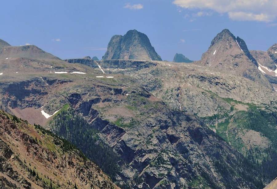
Vestal Peak is the highest summit in the Grenadier Range, deep in the Weminuche Wilderness. It is best known for Wham Ridge, the huge tilted slab on its north side, which is a technical climb. The standard route goes up the other side: the south face, on steep talus, scree and broken rock at about Class 2+, with a few Class 3 moves.
Getting there is most of the work. From Molas Pass you drop about 1,700 feet to the Animas River, climb up Elk Creek to the beaver ponds, then take a steep, unmaintained trail up Vestal Creek to camps near treeline. From camp, you cross into the valley between Arrow and Vestal, boulder-hop a rock glacier to the saddle between the two peaks, contour across the south face and climb a big gully to the summit ridge.
Plan on at least three days. The climb day from a high camp in Vestal Creek is about 7 miles round trip and 6 to 9 hours. Remember the long climb back up to Molas Pass on the way out. This trip suits fit backpackers with scrambling experience and good route-finding skills.
Plan of the day
Start by
Leave the Vestal Creek camp by 5 a.m. You spend most of the day above treeline on talus and in a gully where storms and rockfall are real risks.
Turnaround
If you are not at the Arrow-Vestal saddle by 9:30 a.m., or at the base of the south face gully by 10:30 a.m., turn back.
Crux
The steep gully on the south face, which is loose talus and broken rock at Class 2+ with a few Class 3 moves. It holds snow into July.
Route-finding
The Colorado Trail and Elk Creek trail are easy. The Vestal Creek trail is steep, unmaintained and splits into several paths. Above camp, the rock glacier and the contour across the south face take care; stay below the cliffs and do not climb too early.
Water
Plenty on the approach: Molas Creek, the Animas, Elk Creek, the beaver ponds and Vestal Creek. Filter all of it. Once you leave the Vestal Creek camp, water is only from snowmelt, so carry what you need.
From Silverton, drive south on US 550 toward Molas Pass. About 5.3 miles from the Silverton turnoff, and a little past the Molas Lake road, turn left into the Molas trailhead lot. From Durango, cross Coal Bank and Molas passes; the lot is about 1.1 miles past the top of Molas Pass on the right. The dirt lot is fine for any car but can be muddy and have potholes.
You can also ride the Durango and Silverton train to the Elk Park stop and skip the descent from Molas Pass; check the railroad's current schedule and stops. Camping is available near Molas Lake and Little Molas Lake. Protect your food and gear in Vestal Creek: the marmots there are known to chew through tents, packs and anything salty.
Trail in the treesTalus and screeTundraRidgeScramblingExposed to lightning
The line is elevation, the band underneath is the ground, and the numbered dots match the steps below. Mileage and elevations are approximate.
1
Molas trailhead 10,630' · 0 mi
From the parking lot, take the connector trail south to join the Colorado Trail about half a mile south of Molas Lake. Head east through open, flowery meadows with views of the Grenadiers ahead.
2
Switchbacks to the Animas 9,500' · 2 mi
The trail passes through forest, then breaks out and starts a long drop on 30 or more switchbacks. Garfield, Graystone and Electric peaks are across the valley.
Watch for: Remember you must climb this on the way out.
3
Animas River bridge 8,900' · 3 mi
Cross Molas Creek, then cross the Animas River on a solid footbridge. Walk south along the railroad tracks a short way and look for the Elk Creek trail climbing the slope on your left.
Watch for: Stay off the tracks when a train is coming.
4
Elk Creek trail 9,200' · 3.6 mi
The trail switchbacks up, then contours above the tracks over a low ridge into the Elk Creek drainage. It stays on the north side of the creek and is easy to follow.
5
Bench above Elk Creek 9,900' · 6 mi
The trail climbs above the creek, goes briefly up a side drainage, and reaches a flat bench high above the creek. The climbing is over for now.
6
Beaver ponds 9,950' · 6.5 mi
You will see the beaver ponds to the right of the trail. A path follows the east shore of the largest pond, below a boulder field, then passes through some willows to a clearing with flat campsites.
7
Elk Creek crossing 9,800' · 6.7 mi
Continue south to a steep bank above Elk Creek. Cross on fallen logs if they are there. On the south side, follow a bench west a short way to the base of the Vestal Creek trail.
Watch for: Log crossings change from year to year and can be slick.
8
Avalanche chute 10,700' · 7.7 mi
The unmaintained trail climbs steeply south with lots of fallen trees and several branches. After about a mile you reach a second avalanche chute. Stay on the main trail climbing along the small ridge on the east side of the chute.
Watch for: Avoid the path at the bottom of the chute; it leads off route.
9
Vestal Creek meadow 11,000' · 8.3 mi
The trail drops close to the creek in an open meadow. Looking south-southwest you see up the valley between Electric and Arrow.
10
Upper Vestal Creek camp 11,760' · 9 mi
Continue through forest to a lower meadow at 11,300 feet, then about a third of a mile more to a camp in the last open trees beside the creek at 11,760 feet. Arrow, Vestal and the Trinities tower above.
Watch for: Hang or guard food and gear from marmots.
11
Arrow-Vestal valley 12,000' · 9.8 mi
From camp, contour west across rock benches and grassy shelves into the valley between Arrow and Vestal.
Vestal and Arrow from the valley · Photo: Doug Lynne
12
Rock glacier 12,400' · 10.6 mi
Most of this valley is a rock glacier. Head south-southwest, boulder-hopping with little tundra to rest on.
Watch for: Talus can shift. Take your time.
13
Arrow-Vestal saddle 12,900' · 11.2 mi
Climb talus and scree to the saddle between Arrow and Vestal. Early in the season this slope holds snow. Wham Ridge is out of sight on the other side of Vestal.
Watch for: Snow here early in the season. Ice axe needed.
14
South face contour 13,200' · 11.8 mi
From the saddle, head east on a cairned climber's trail that angles across the lower west ridge and south face. Stay below the cliffs at around 13,200 feet. A shallow gully rises directly below the summit; the larger couloir on the southeast face is a bit farther east.
Watch for: Do not climb up into the cliffs too early.
15
South face gully 13,600' · 12.2 mi
Climb the large gully, staying on its west side on broken rock and talus. Most of it is Class 2+, with a few Class 3 moves. Early in the season the center holds steep snow.
Watch for: Rockfall. Stay out of the line of other climbers.
16
Summit 13,867' · 12.5 mi
Top out on the ridge a little east of the summit and walk west to the high point. Look down the length of Wham Ridge and across to Arrow, the Trinities and the Needle Mountains.
Here Molas Lake Trail goes off to the left. Keep going straight on Molas - Colorado Trail.
Coming down: Keep going straight on Molas - Colorado Trail. Don’t take Molas Lake Trail.
2Mile 5.6 · 9,780'
Keep left to stay on Elk Creek / Colorado Trail
Here Elk Park Spur goes off to the right. Keep left to follow Elk Creek / Colorado Trail.
Coming down: Keep right to stay on Elk Creek / Colorado Trail. Don’t take Elk Park Spur.
Landmarks to know
Open meadows on the Colorado Trail with the Grenadiers ahead.
The footbridge over the Animas River and the Elk Creek trail just south along the tracks.
The beaver ponds with a boulder field on the east edge of the main pond.
A second avalanche chute on the Vestal Creek trail, with the main path on the ridge to its east.
The last open trees beside Vestal Creek at about 11,760 feet.
A rock glacier filling the valley between Arrow and Vestal.
The Arrow-Vestal saddle and the cairned path east below the south face cliffs.
The large gully on the southeast part of the south face.
Getting down
Go down the same way. From the summit walk east a short way to the top of the gully you climbed. Make sure you pick the right one; other gullies on this face lead to cliffs. Descend slowly on loose rock and scree, and keep the group close together to limit rockfall.
At the bottom of the gully, contour west below the cliffs back to the Arrow-Vestal saddle before dropping north. Coming down the rock glacier, aim for the valley exit and contour east back to camp. On the hike out, the Vestal Creek trail has several branches; stay on the main line and avoid the path at the bottom of the avalanche chute.
If things go wrong
The Arrow-Vestal saddle and the valley below it are the nearest safer ground. If weather turns while you are in the gully, head straight down and back west to the saddle, then drop into the valley and return to camp. Do not try to descend unknown gullies on the south face. This area is very remote, and the way out includes a long climb back to Molas Pass. If someone is hurt, keep them warm and still, and send for help or use a satellite messenger. Call 911 if you have a signal. A rescue can take many hours.
3D flyover
Press play to fly the South Face. The graph shows elevation along the way and how much you gain each mile. Open full screen.
For planning only. The line is traced from open map data, not walked in the field, and off-trail parts are drawn straight. Load it in your GPS app to see the route, but navigate with your eyes, a map and the route description.
See the trail on video
A climb of this route filmed by Kristen Bowling. The video belongs to them and only plays when you press play.
This describes the route on a dry summer day. Snow, ice, a washed-out road or an afternoon storm can make it a very different climb. Check recent conditions the week you go and turn around when the day tells you to.