Afternoon storm risk is the line that matters. Everything else is comfort. In summer, plan to be off the ridge before the build-up starts, not as it starts. Forecast for the summit point, adjusted for its elevation · data from Open-Meteo.
This is a snow climb. It is only safe when the snow is firm and stable, usually early in the morning in late spring and early summer. You need an ice axe, crampons, a helmet and the skills to use them. Check avalanche conditions before you go.
Snow route · Kirk Couloir
Overview
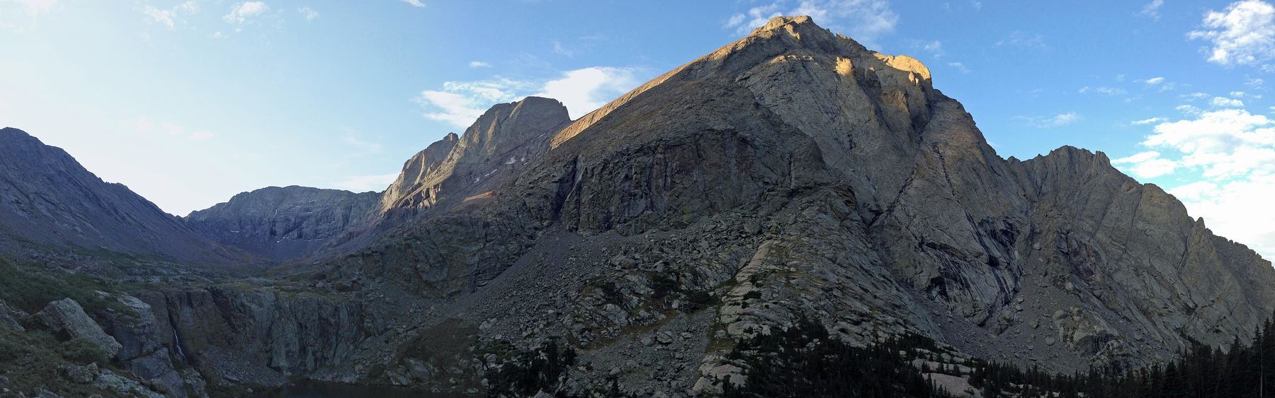
The Kirk Couloir is a steep snow climb on Challenger Point. It is a narrow gully that splits the cliffs between Challenger and Kit Carson Peak. You hike to Willow Lake, cross the basin above it, climb snow slopes to the couloir, go up more than 200 feet of snow near 50 degrees, and then walk to the Kit Carson and Challenger saddle and the summit.
This is a Class 3, steep snow route for climbers who can use an ice axe and crampons with skill. It is much harder than the standard route up Challenger's north slopes. The couloir is short but steep, and a fall there would be serious. The trip is about 12.75 miles round trip with about 5,400 feet of gain.
Plan on 10 to 13 hours car to car, or split it by camping near Willow Lake.
Plan of the day
Start by
Very early, often 2 to 3 a.m. from the car, or before dawn from a camp at the lake. You want to be in and out of the couloir while the snow is still firm.
Turnaround
Be at the base of the couloir by about 8 a.m. If the snow is soft, slushy, or wet slides are running, turn around.
Crux
The couloir itself. It starts near 45 degrees and steepens to almost 50 degrees for more than 200 feet before the exit.
Route-finding
Moderate. Most of the route is visible from the flat spot above the waterfall by the lake. Aim for the narrow gully between the cliffs of Kit Carson and Challenger.
Water
Willow Creek and Willow Lake along the approach. Filter it. There is little running water high up in early season, so carry 2 to 3 liters from the lake.
Drive Colorado 17 to Moffat. At the south end of town, go east toward Crestone and drive about 11.5 miles to Crestone. Go straight into town, turn left on Alder Street, then right on Galena.
Follow Galena out of town. It becomes a dirt Forest Service road. The trailhead is about 2 miles up this road. Most cars can reach it in dry conditions.
Talus and screeTundraSnow or couloirRidgeExposed to lightning
The line is elevation, the band underneath is the ground, and the numbered dots match the steps below. Mileage and elevations are approximate.
1
Willow Creek trailhead 8,900' · 0 mi
Take the Willow Lake trail up the valley. It climbs a long series of switchbacks and then follows the creek into the upper basin.
Watch for: Long approach. Keep a steady pace in the dark.
2
West end of Willow Lake 11,560' · 4.6 mi
Near the lower end of the lake, keep left on the trail. Leave the trees and cross a boulder field on a slope.
3
Flat area above the waterfall 11,600' · 4.9 mi
Reach the flat ground above the falls at the upper end of the lake. Much of the route is visible from here, including the narrow couloir between the cliffs.
Watch for: Good spot to put on crampons if the snow starts here.
4
Base of Challenger's north slopes 11,900' · 5.2 mi
Cross the stream and follow cairns and bits of trail across the flat. Above 11,800 feet, angle left through willows and brush to the foot of Challenger's north slopes.
5
Flat area near 12,200 feet 12,200' · 5.5 mi
As the ground opens up, head south over gentle terrain toward the couloir. Pass a flat spot, then the slope starts to steepen.
6
Steep slopes below the couloir 12,900' · 5.8 mi
Above 12,900 feet the snow gets much steeper as you near the couloir entrance. Put on your helmet if you have not already.
Watch for: A slip here can slide a long way. Keep your axe ready.
7
Couloir entrance 13,100' · 5.95 mi
Turn right into the couloir. The snow starts at about 45 degrees.
Watch for: Rock and ice can fall from the cliffs on both sides.
8
Couloir exit 13,350' · 6.05 mi
Climb more than 200 feet of snow that gets close to 50 degrees. The exit comes into view near the top. Climb out onto easier ground.
Watch for: This is the steepest part of the route. Kick solid steps and keep three points of contact.
9
Kit Carson and Challenger saddle 13,780' · 6.25 mi
Walk up from the couloir exit to the saddle between the two peaks.
10
Summit of Challenger Point 14,081' · 6.4 mi
At the saddle, go right; the summit is about 300 feet above.
Getting down
Downclimbing the couloir is steep and slow and only makes sense in firm, stable snow. Many parties instead descend Challenger's standard north slopes route back to Willow Lake. It is less steep but is loose and can hold snow too. Either way, get off the snow before it turns soft in the midday sun. From the lake, follow the trail back down to the trailhead.
If things go wrong
Below the couloir, you can turn around at any point and retrace your steps to the lake. Once in the couloir, going up is often safer than going down, unless conditions are bad. If the snow is too soft, wet slides start, or rocks are falling, back off before you commit. Call 911 if someone is hurt. Help can take many hours to reach this basin.
Other routes
Every way up Challenger Point we list, with its class.
This describes the route in its usual season. Distances and elevations are close estimates for planning. Snow, ice, rockfall, a washed-out road or an afternoon storm can make it a very different climb. Check recent conditions the week you go and turn around when the day tells you to.