Afternoon storm risk is the line that matters. Everything else is comfort. In summer, plan to be off the ridge before the build-up starts, not as it starts. Forecast for the summit point, adjusted for its elevation · data from Open-Meteo.
Standard route · Northeast Ridge
Overview
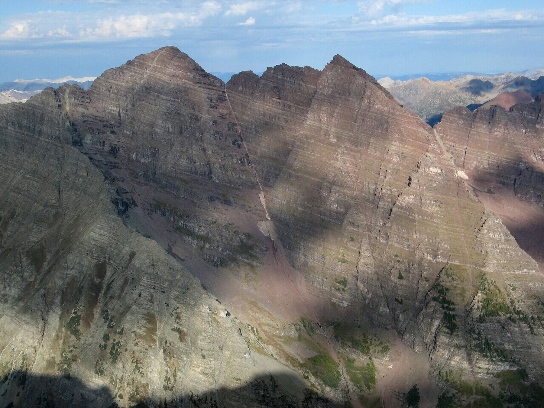
North Maroon Peak is one of the most dangerous standard 14er routes in Colorado. It is 9.25 miles round trip with about 4,600 feet of gain from Maroon Lake. Most parties take 10 to 13 hours. The route crosses a rock glacier, climbs two steep gullies onto the northeast ridge, passes a rock band with a Class 4 chimney, and then follows an exposed ridge to the summit.
The Maroon Bells are made of rotten, layered sedimentary rock. Holds break, ledges are covered in gravel, and rockfall is constant. Almost the whole upper route has serious fall danger, and the route-finding is complex. Small mistakes here have killed experienced climbers.
This climb is only for people with solid Class 3 and Class 4 scrambling experience, good route-finding skills, and capable partners. It is not a place to learn. If you are unsure, hire a certified guide from an established guide service, or pick another peak. Wear a helmet the whole time above the rock glacier.
Plan of the day
Start by
By 3:30 to 4 a.m. It is a long day, the upper route is slow, and storms often form over the Elk Range by late morning.
Turnaround
If you are not at the entrance to the 2nd gully (about 12,700 feet) by 9 a.m., turn around. If you are not at the rock band at 13,500 feet by 10:30 a.m., turn around. Turn back at once if weather starts to change after the 2nd gully.
Crux
The rock band at 13,500 feet, climbed either by a Class 4 chimney or a Class 3 break about 150 feet to the right. The exposed ledges on the ridge edge above it, in the final 300 feet, are also very serious.
Route-finding
Hard. The approach trail is clear, but the rock glacier crossing, the exit from the 1st gully, the ledge traverse to the 2nd gully, and the notch at the top of the 2nd gully are all places people get lost. Getting off route on this peak often means cliffs.
Water
Maroon Lake, Maroon Creek, and the creek in Minnehaha Gulch. There is no reliable water above the gulch. Filter everything. Carry 3 liters or more from the last creek.
Paved road to a massive lot, but strictly regulated. You must reserve a shuttle bus ticket or parking pass months in advance; private cars are often banned between 8 AM and 5 PM.
Terrain
Gentle tourist paths around a stunning reflective lake that abruptly turn into steep, loose, crumbling red mudstone cliffs.
You start on one of the most photographed trails in America, walking smoothly around Maroon Lake with the "Bells" towering above. As you turn toward the peaks, the trail steepens aggressively through rocky scree fields. Once you hit the upper mountain, the "hiking" ends. The rock here is notoriously loose and rotten—every hold must be tested. You will find yourself carefully scrambling up steep, red dirt gullies and loose rock ledges where a single slip can send rocks tumbling onto climbers below. It is physically demanding, mentally exhausting, and visually spectacular.
Drive to Aspen and find the Maroon Creek Road at the roundabout on the west side of town. Measuring from the roundabout, pass a ranch at about 3.2 miles and reach the Forest Service entrance station at about 4.7 miles. The trailhead at Maroon Lake is at about 9.5 miles. The road is paved.
In summer the road past the entrance station is closed to private cars during the day, roughly 8 a.m. to 5 p.m., when a bus runs. Parking at the trailhead needs a reservation made ahead of time, and space is limited. For this climb you will want to arrive well before the daytime closure. Camping near Crater Lake also needs a separate permit. Check the current rules before your trip.
Trail in the treesTalus and screeTundraScramblingExposed to lightning
The line is elevation, the band underneath is the ground, and the numbered dots match the steps below. Mileage and elevations are approximate.
1
Maroon Lake trailhead 9,590' · 0 mi
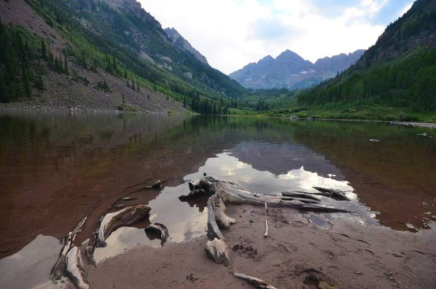
From the trailhead, walk west on the trail along the edge of Maroon Lake. On a clear morning you can see much of the North Maroon route from here: the north face above the rock glacier and the long northeast ridge.
2
End of Maroon Lake 9,650' · 0.4 mi
Pass the upper end of the lake and start up the Crater Lake trail. It climbs through aspen and over rocky ground.
Maroon Lake below the Bells · Photo: Sayamindu Dasgupta
3
Maroon-Snowmass trail junction 10,000' · 1.8 mi
About 1.75 miles past the lake, reach a trail junction just before Crater Lake. Turn right onto the Maroon-Snowmass trail.
Watch for: Do not continue to Crater Lake. That is the route to Maroon Peak.
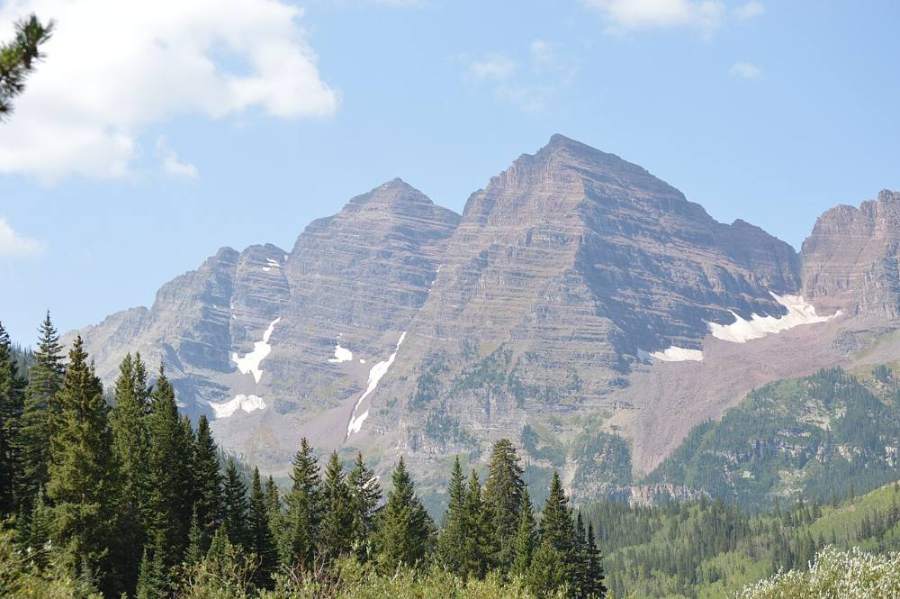
The Maroon Bells from Crater Lake · Photo: Whyleesaa
4
North Maroon turnoff 10,300' · 2.55 mi
Follow the Maroon-Snowmass trail for about 0.75 mile to the junction for North Maroon. Turn left.
Watch for: This junction is easy to miss in the dark.
5
Minnehaha Gulch creek 10,250' · 2.65 mi
The trail drops into Minnehaha Gulch. Cross the creek. This is the last good water.
Watch for: Last reliable water on the route.
6
Talus switchbacks 10,800' · 2.9 mi
Follow the clear trail as it zigzags up through talus fields.
7
Under the cliffs 11,100' · 3.1 mi
Near 11,100 feet, turn left below cliffs and continue to another talus field.
8
Grassy bench 11,500' · 3.3 mi
Around 11,500 feet you reach an open grassy area. North Maroon comes back into view. Ahead is the rock glacier at the base of the north face.
9
Rock glacier 11,700' · 3.45 mi
Follow cairns and bits of trail onto the rock glacier, a field of large boulders. Aim for a break in the cliffs on the far side. Try to stay at about the same height as you cross, and follow the cairns.
Watch for: Big, unstable boulders. Test before you step.
10
1st gully view corner 11,950' · 3.6 mi
Past the rock glacier, pick up a clearer trail and follow it south around a corner. Turn right and climb about 200 feet below cliffs. At about 11,950 feet you reach a corner where you can see a broad gully leading up to the northeast ridge. This is the 1st gully.
11
1st gully 12,300' · 3.75 mi
Enter the gully and climb along its left side. It is steep Class 2 for about 600 feet. White cliffs are visible above. Above 12,600 feet, follow the trail left and out of the gully, below those cliffs.
Watch for: Rockfall from parties above. Stay to the side and keep your helmet on.
12
Ledges to the 2nd gully 12,700' · 3.9 mi
Turn another corner and traverse across ledges to the entrance of the 2nd gully, near 12,700 feet. From here the climbing gets much harder and slower.
Watch for: Last good turnaround point before the hardest terrain.
13
2nd gully to the notch 13,100' · 4.1 mi
Drop slightly to the center of the gully, then climb it. It is steeper and looser than the 1st. Above 12,900 feet, take a faint path up the gully's left side, aiming for a notch in the ridge that sits just left of a big hump of rock. Once at the notch, go left and work up through cliff bands.
Watch for: Very loose. Scrambling near the top. Do not knock rocks onto people below.
14
Northeast ridge 13,300' · 4.2 mi
Reach the ridge crest at about 13,300 feet. Follow it a short way up to a band of rock that blocks the ridge.
15
Rock band and chimney 13,500' · 4.3 mi
At 13,500 feet, choose your line. The Class 4 chimney is below two leaning blocks. The Class 3 option climbs a break in the band about 150 feet to the right (west). If you start the chimney and feel unsure, climb down and use the bypass. Above the chimney, go right, then climb left back to the crest. Above the bypass, turn left and head back up to the crest.
Watch for: The chimney got harder in 2025 when a key rock came loose. Test every hold.
16
Summit 14,022' · 4.6 mi
Back on the crest, climb onto a high point where you can see the final 300 feet. Leave it and climb the exposed edge of the ridge on steep ledges. Then easier ground leads to a short, rocky walk to the summit. Maroon Peak is just to the south across a sharp ridge.
Watch for: Big exposure on the ledges below the summit. Do not try the traverse to Maroon Peak unless you are ready for Class 4 climbing.
Here Maroon Bells Connector goes off to the left. Turn right to follow Maroon-Snowmass Trail.
Coming down: Turn left to stay on Maroon-Snowmass Trail. Don’t take Maroon Bells Connector.
2Mile 1.7 · 9,980'
Turn right to stay on the main trail
Here an unmarked path goes off to the left. Turn right to follow the main trail.
Coming down: Turn left to stay on the main trail. Don’t take the unmarked path.
3Mile 2.0 · 10,080'
Keep right to stay on Maroon-Snowmass Trail
Here an unmarked path goes off to the left. Keep right to follow Maroon-Snowmass Trail.
Coming down: Keep left to stay on Maroon-Snowmass Trail. Don’t take the unmarked path.
Landmarks to know
The junction before Crater Lake, where you turn right on the Maroon-Snowmass trail.
The North Maroon turnoff and the drop into Minnehaha Gulch.
The open grassy bench near 11,500 feet with the north face in view.
The rock glacier at the base of the north face.
The corner at about 11,950 feet with the broad 1st gully in view.
White cliffs where you exit the 1st gully above 12,600 feet.
A notch in the ridge just left of a large rock hump at the top of the 2nd gully.
The rock band at 13,500 feet with two leaning blocks above the chimney.
Getting down
Go down the same way, and treat the descent as the most dangerous part of the day. Many accidents on this peak happen going down. Down-climb the ledges below the summit facing in. At the rock band, the Class 3 break is often easier to go down than the chimney. Keep your group close and move one at a time where rock can fall.
The big mistake is leaving the ridge at the wrong point or dropping down the wrong gully. Find the notch at the top of the 2nd gully and go down through the cliff bands to it. At the bottom of the 2nd gully, traverse the ledges back to the 1st gully. Do not keep descending the 2nd gully, and do not try to go straight down the north face; both lead to cliffs. Take note of these spots on the way up so you know them on the way down. Below the 1st gully, go back around the corners, across the rock glacier, and down the trail.
If things go wrong
There are no safe shortcuts off this peak. The only way down is the way you came. The entrance to the 2nd gully at 12,700 feet is the main point to turn back; above that, retreat is slow. If weather turns, stop climbing and start down right away, carefully; rushing on loose rock causes falls. Get off the ridge and into the gullies, then out to the rock glacier and the grassy bench below it. If someone is hurt, protect them from rockfall, keep them warm, and call 911. Cell coverage is limited and a rescue here is slow and difficult. Carry a satellite messenger.
3D flyover
Press play to fly the Northeast Ridge. The graph shows elevation along the way and how much you gain each mile. Open full screen.
For planning only. The line is traced from open map data, not walked in the field, and off-trail parts are drawn straight. Load it in your GPS app to see the route, but navigate with your eyes, a map and the route description.
See the trail on video
A climb of this route filmed by Vo2maxProductions. The video belongs to them and only plays when you press play.
Jump to
Other routes
All 2 routes up North Maroon Peak, with the class and round-trip distance for each.
A committing high-altitude alpine link-up across crumbling, highly unstable maroon mudstone. You navigate a razor-thin ridge connecting the two summits, climbing up exposed chimneys and bypassing rotten towers where every handhold must be pulled downward rather than outward to prevent total structural failure of the rock.
Do not make this an introduction to anything
Class 4 is exposed climbing where a slip is likely fatal and the rock is often loose. This demands prior Class 3 and Class 4 experience, flawless route-finding, a helmet and a partner who knows the line. Treat any trip report, including this one, as one person’s day rather than a guarantee of yours.