Afternoon storm risk is the line that matters. Everything else is comfort. In summer, plan to be off the ridge before the build-up starts, not as it starts. Forecast for the summit point, adjusted for its elevation · data from Open-Meteo.
Standard route · South Ridge
Overview
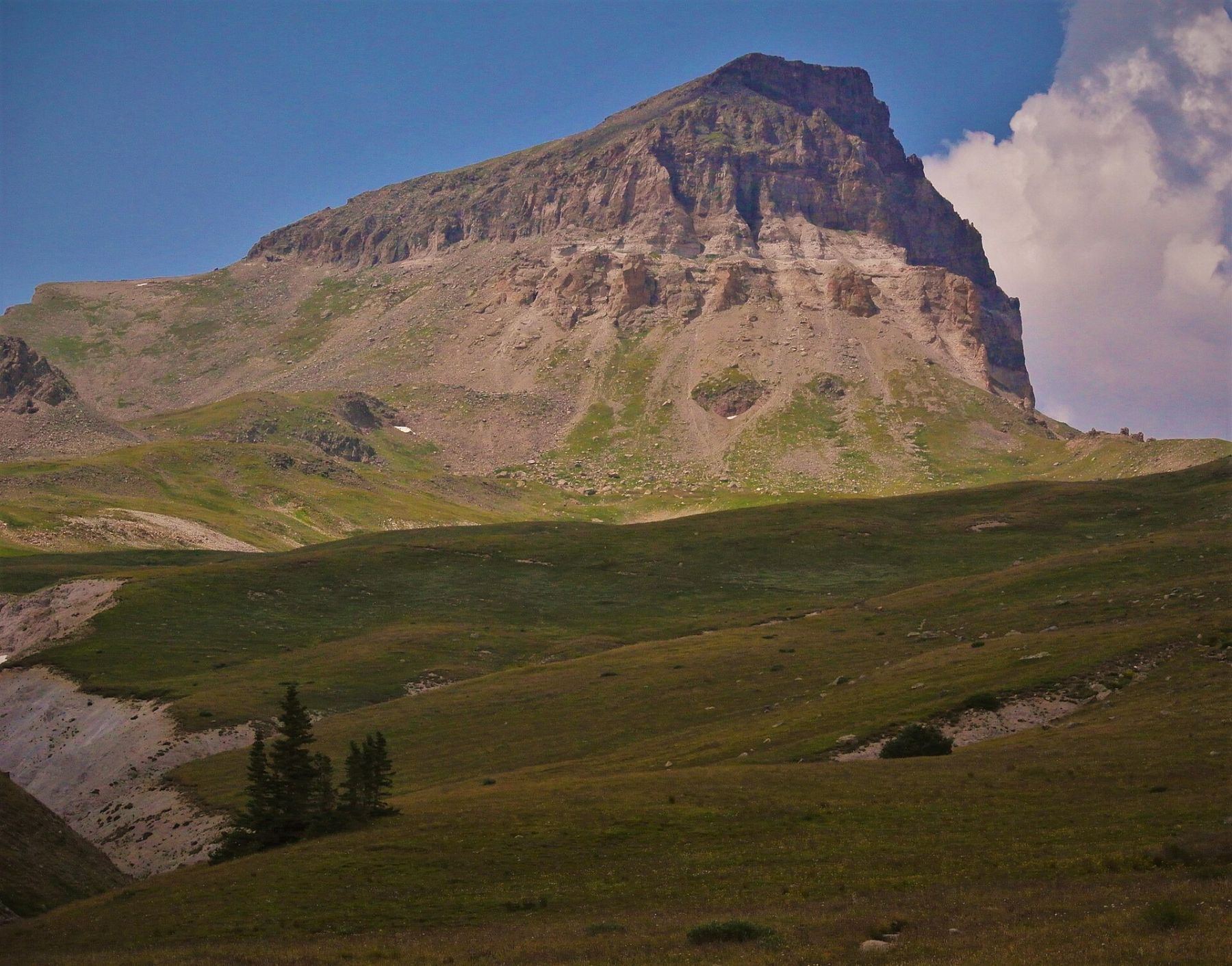
Uncompahgre is the tallest peak in the San Juan Mountains. From most sides it looks like a tilted table: a broad, gentle summit plateau that ends at a sheer cliff on the north side. The standard route starts high, at the end of the Nellie Creek 4WD road, and follows a good trail across an open basin and up the long south ridge. Most of the day is easy walking. The last few hundred feet are not.
The crux is a short band of steep, broken rock on the west side of the ridge, about 400 feet below the top. It is only about 150 feet tall, but it is loose, it is Class 2 scrambling with hands, and rocks knocked off by people above you come straight down. Above it, a clear path leads over gentle slopes to the flat summit. The north edge of the summit drops away hundreds of feet, so stay back from it, especially in fog or wind.
From the 4WD trailhead the round trip is 7.5 miles with about 3,000 feet of gain. Most fit hikers take 5 to 7 hours. If you cannot drive the 4WD road, the hike from Henson Creek adds 8 miles and about 2,500 feet, which makes for a long day. This is a good step up for someone who has done a few Class 1 fourteeners and wants a first taste of loose Class 2 rock.
Plan of the day
Start by
Be walking by 5:30 a.m. from the 4WD trailhead, or by 3:30 a.m. if you start from Henson Creek. Almost the whole route is above treeline and San Juan storms often build before noon.
Turnaround
If you are not at the base of the rock band on the west side of the ridge (about 13,900 feet) by 11 a.m., or if clouds are building fast, turn around there. You do not want to be on loose rock in rain or lightning.
Crux
About 150 feet of steep, loose Class 2 rock on the west face below the summit slopes. Holds and stones shift easily, and rockfall from other climbers is a real risk.
Route-finding
Easy to follow to the ridge crest near 13,800 feet. In the rock band the trail breaks up into several loose paths; aim for the rock tower, then work right back up to the ridge. Note where you came up so you can find the same line on the way down.
Water
Nellie Creek runs beside the trail in the first mile and through the lower basin. There is no reliable water above about 12,000 feet. Filter or treat anything you take.
From Lake City, turn west on Second Street, then left after about a block onto Bluff Street. This becomes the Henson Creek road (part of the Alpine Loop). Drive about 5 miles west to the Nellie Creek road on the right, marked as trail 877. Cars without high clearance and 4WD should park here along Henson Creek and walk the road.
The Nellie Creek road climbs 4 miles to the trailhead at 11,400 feet. It is narrow, steep and rocky, with little room to pass. You cross Nellie Creek at about 1.8 miles, keep left at a fork at about 2.3 miles, and cross the creek again at about 2.7 miles. In early summer the creek crossings can run high and fast. Parking at the top is limited, so arrive early. The route enters the Uncompahgre Wilderness, which has its own rules on group size, camping, fires and dogs; check with the Forest Service before you go.
TundraTalus and screeRidgeExposed to lightning
The line is elevation, the band underneath is the ground, and the numbered dots match the steps below. Mileage and elevations are approximate.
1
Nellie Creek trailhead 11,400' · 0 mi
Start from the upper end of the parking area. The trail climbs gently through spruce with Nellie Creek off to your side. You reach the last trees in under half a mile.
2
Treeline 11,600' · 0.5 mi
The forest opens into willows and meadow. The trail stays close to the creek and is wide and easy to follow. This is the last good place to fill water.
Watch for: Early season, snow can linger in the shade here.
3
Big boulders by the creek 11,800' · 0.8 mi
The trail passes a group of large boulders as it runs alongside the stream. Keep going up the valley on the main path.
4
Trail junction 11,950' · 1.1 mi
After a short climb up a small hill you reach a junction at the edge of a wide basin. Uncompahgre's summit block is now in view to the north, with its tilted top. Continue west into the basin.
Watch for: Stay on the Uncompahgre trail, not a side path.
5
Across the basin 12,400' · 1.6 mi
Turn left and follow the trail southwest across the open basin. It is grassy, rolling ground. The long ridge ahead of you is the south ridge; the trail angles toward its low point.
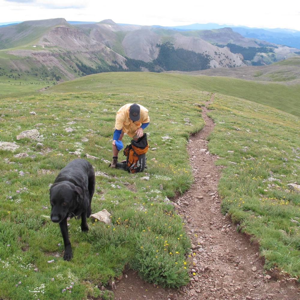
The trail through the upper basin · Photo: OakleyOriginals
6
Gain the south ridge 12,900' · 2.3 mi
The trail tops out on the south ridge. The views open up to the south and west over the San Juans. Turn right and follow the ridge west and northwest toward the peak.
Watch for: From here on you are exposed to wind and lightning with no shelter.
7
Along the ridge 13,300' · 2.8 mi
The trail follows the broad ridge on good tread, rising steadily. Ahead the ridge runs into the southeast face of the summit block.
8
Switchbacks on the southeast face 13,600' · 3.1 mi
The trail climbs a set of switchbacks up the face on looser, rockier ground. Take your time and keep a steady pace.
Watch for: Loose gravel on the switchbacks.
9
Ridge crest 13,800' · 3.3 mi
You reach the crest of the ridge again. The trail now bends left and wraps onto the west side of the peak.
10
Base of the rock band 13,900' · 3.4 mi
On the west face you meet a short wall of steep, broken rock about 150 feet tall. Look for a rock tower up ahead; that is your target. Put your helmet on here if it is not on already.
Watch for: Check the time and the sky here. This is your turnaround point.
11
Through the rock band 14,050' · 3.5 mi
Scramble up loose Class 2 ground toward the tower. You can climb past the tower and then cut right back to the ridge, or take a slightly steeper line just before the tower. Both are loose. Test each hold and move one person at a time in gullies.
Watch for: Rockfall from people above you. Do not stand directly below others.
12
Upper slopes 14,200' · 3.65 mi
The terrain eases and a clearer path appears. Follow it up easy, rocky slopes toward the top.
13
Summit 14,318' · 3.75 mi
The top is a large, nearly flat area. The north side ends in a huge cliff. Enjoy the view over Wetterhorn and the rest of the San Juans, but stay well back from the north edge.
Watch for: Sheer drop on the north side. Stay away from the edge in fog or wind.
Here Big Blue Creek Trail 232 goes off to the left. Keep left to follow Uncompahgre Peak Trail 239.
Coming down: Turn sharp right to stay on Uncompahgre Peak Trail 239. Don’t take Big Blue Creek Trail 232.
2Mile 2.4 · 12,980'
Turn right to stay on Uncompahgre Peak Trail 239
Here Ridge Stock Driveway Trail 233 goes off straight ahead. Turn right to follow Uncompahgre Peak Trail 239.
Coming down: Turn left to stay on Uncompahgre Peak Trail 239. Don’t take Ridge Stock Driveway Trail 233.
3Mile 2.7 · 13,220'
Stay on Uncompahgre Peak Trail 239
Here Informal Connector goes off to the left. Keep going straight on Uncompahgre Peak Trail 239.
Coming down: Keep going straight on Uncompahgre Peak Trail 239. Don’t take Informal Connector.
Landmarks to know
Nellie Creek beside the trail in the first mile.
A group of large boulders next to the creek near 11,800 feet.
A trail junction at the edge of a wide basin, with the tilted summit block in view.
The long south ridge ahead of you across the basin.
Switchbacks up the southeast face to the ridge crest near 13,800 feet.
A rock tower on the west face marking the loose rock band.
A broad, flat summit that ends at a sheer north cliff.
Getting down
Go back the way you came. Walk south from the summit on the clear path to the top of the rock band. Before you start down, look for the line you used coming up. Down-climbing loose rock is harder than going up, so face in where it is steep and keep your weight over your feet.
In the rock band, spread out so you are not below anyone else. Once back on the ridge crest near 13,800 feet, follow the switchbacks down the southeast face and the south ridge. Leave the ridge at the low point and cross the basin to the northeast. Do not continue east down the ridge past where the trail turns off.
If things go wrong
Before the rock band, you can turn around at any point and the trail back is easy to follow. The quickest way off high ground is to retrace the south ridge and drop into the Nellie Creek basin, which gets you below 12,500 feet within a mile or two. If a storm hits while you are in the rock band, get down it carefully rather than rushing, then move off the ridge. If someone is hurt, keep them warm and out of the wind, send someone to find a cell signal on the ridge if needed, and call 911. Rescue here is slow, so pack enough to wait for hours.
3D flyover
Press play to fly the South Ridge. The graph shows elevation along the way and how much you gain each mile. Open full screen.
For planning only. The line is traced from open map data, not walked in the field, and off-trail parts are drawn straight. Load it in your GPS app to see the route, but navigate with your eyes, a map and the route description.
See the trail on video
A climb of this route filmed by Wannabe Alpinist. The video belongs to them and only plays when you press play.
Other routes
All 1 route up Uncompahgre Peak, with the class and round-trip distance for each.
Expect talus, scree and stretches where the trail disappears. Ankles and weather cause most of the trouble here. Start early, keep an eye on the sky, and set a turnaround time before you leave the car.