Afternoon storm risk is the line that matters. Everything else is comfort. In summer, plan to be off the ridge before the build-up starts, not as it starts. Forecast for the summit point, adjusted for its elevation · data from Open-Meteo.
Centennial 13er · North Ridge
Overview
Gladstone Peak sits in the middle of the San Miguel Mountains near Telluride, boxed in by Wilson Peak, Mount Wilson and El Diente. It is one of the loosest peaks in Colorado. This route follows the Wilson Peak trail from the Rock of Ages trailhead over a high saddle into Navajo Basin, then climbs Gladstone's north ridge. The ridge is exposed Class 4 on big, loose blocks, with long drops on both sides.
The trail to Rock of Ages saddle is well built and easy to follow. Past the saddle, the terrain becomes rough talus and then a narrow ridge of stacked rock that shifts under your weight. Almost every hold needs testing. This route is only for climbers with solid Class 4 experience on loose rock, who are comfortable with serious exposure and who move well together as a team. A helmet is a must.
The round trip is about 11.25 miles with roughly 4,100 feet of gain. Plan on 10 to 12 hours. Much of the day is above 12,000 feet, and the ridge is slow, so start very early.
Plan of the day
Start by
By 4 a.m. It takes 3 or more hours just to reach Rock of Ages saddle, the ridge is slow going, and storms often build over these peaks by late morning.
Turnaround
If you are not at the base of the north ridge by 9:30 a.m., turn around. If you are not on the summit by 11 a.m., turn around wherever you are on the ridge.
Crux
The north ridge itself. It is narrow, very exposed Class 4 on large loose blocks. Stay close to the crest; dropping off it leads into worse rock.
Route-finding
Easy on the trail to Rock of Ages saddle. Past the saddle the trail toward Wilson Peak is clear for a while. The ridge requires steady route-finding. The main mistake is leaving the crest to bypass towers and ending up on steep, rotten slopes below it.
Water
Water is available from streams in the lower valley and in Silver Pick Basin early in the season. There is little or no water above the saddle later in summer. Carry what you need for the ridge and filter or treat all water; there are old mines throughout the area.
From Placerville, drive southeast on Highway 145 toward Telluride. Turn right (south) onto Silver Pick Road (Forest Road 622). Follow it uphill for several miles to the Rock of Ages trailhead, at about 10,350 feet. The road passes through private land, so stay on the road and respect posted signs.
The road is graded dirt and most cars can make it when it is dry. It gets rougher near the end, and high clearance helps. The lot can fill on summer weekends because it also serves Wilson Peak.
Trail in the treesTalus and screeRidgeScramblingExposed to lightning
The line is elevation, the band underneath is the ground, and the numbered dots match the steps below. Mileage and elevations are approximate.
1
Rock of Ages trailhead 10,350' · 0 mi
Start on the Rock of Ages trail at the upper end of the lot. It climbs steadily through aspen and conifer forest. The trail is wide and well marked.
2
Forest traverse 10,900' · 0.9 mi
The trail climbs across the hillside with a few switchbacks. You start to get views of the Wilson peaks to the south. Stay on the main trail at any junctions and follow signs toward Rock of Ages and Wilson Peak.
3
Silver Pick Basin 11,600' · 2 mi
You come out of the trees into the open basin. Old mine ruins, rusted metal and tailings piles dot the slopes. The rocky Rock of Ages saddle is visible high ahead, to the south-southeast.
Watch for: Stay out of mine buildings and openings. They are unstable.
4
Switchbacks below the saddle 12,400' · 2.9 mi
The trail switchbacks up rocky slopes toward the saddle. The footing turns to scree and small talus. Keep a steady pace; this is the longest sustained climb on the trail.
5
Rock of Ages saddle 13,030' · 3.5 mi
You reach the saddle and look south into Navajo Basin for the first time. Gladstone is the big, dark peak across the basin, with Mount Wilson and El Diente beyond it. Check your time and the sky here.
Watch for: First key decision point. If it is late or clouds are building, turn back here.
6
Traverse into Navajo Basin 12,800' · 3.9 mi
Drop a short way off the saddle and follow the trail as it traverses across the upper basin toward Wilson Peak. The trail is rocky and narrow in spots, crossing talus and scree slopes.
Watch for: Loose scree on the traverse. Watch your feet.
7
Toward the Wilson-Gladstone ridge 13,100' · 4.4 mi
Leave the Wilson Peak route where it turns up toward that summit. Head south across talus toward the low part of the ridge running north from Gladstone. Pick a line that keeps you out of loose gullies.
Watch for: Snow can linger on this slope early in the season.
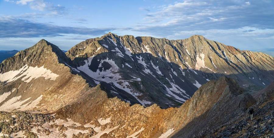
Gladstone and Mount Wilson from the approach · Photo: Kylie Stewart
8
Base of the north ridge 13,300' · 4.8 mi
Reach the crest of Gladstone's north ridge. The ridge runs south to the summit over a series of blocky humps. Put your helmet on if it is not on already. Look it over before you commit.
Watch for: Last good place to turn around before the hard climbing.
9
Lower north ridge 13,450' · 5 mi
Start up the ridge on large, stacked blocks. Stay on or very near the crest. When you have to go around an obstacle, pass it close to the crest on the east (left) side and then return to the ridge.
Watch for: Many large blocks are loose. Test every hold before you weight it.
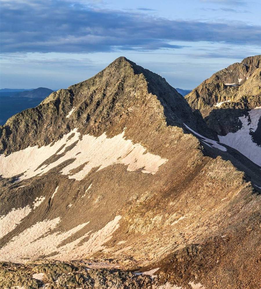
Gladstone Peak's north ridge · Photo: Kylie Stewart
10
Mid ridge 13,650' · 5.25 mi
The ridge narrows and the exposure grows, with long drops on both sides. The climbing is steep in places, and you will need your hands often. Keep your group close together so falling rock cannot build speed.
Watch for: Severe exposure. Do not drop more than a few feet below the crest.
11
Upper ridge 13,800' · 5.45 mi
The last section has the hardest moves. Climb carefully over and around big, shifting blocks. Take your time and keep three points of contact.
Watch for: This is the crux. A single loose block can knock a climber off the ridge.
12
Summit 13,923' · 5.6 mi
The top is a narrow perch of rock with close views of Mount Wilson, El Diente and Wilson Peak. Rest briefly, then start the ridge descent while you still have plenty of time and good weather.
Watch for: The descent is as hard as the ascent. Leave enough time and energy for it.
Here Wilson Mesa Trail goes off to the right. Turn left to follow Rock of Ages Trail.
Coming down: Turn right to stay on Rock of Ages Trail. Don’t take Wilson Mesa Trail.
2Mile 1.3 · 11,150'
Turn left to stay on Rock of Ages Trail
Here Elk Creek Trail goes off to the right. Turn left to follow Rock of Ages Trail.
Coming down: Turn right to stay on Rock of Ages Trail. Don’t take Elk Creek Trail.
3Mile 2.3 · 11,870'
Keep right to stay on Rock of Ages Trail
Here Bedrock Placer Rd2 Road goes off straight ahead. Keep right to follow Rock of Ages Trail.
Coming down: Keep going straight on Rock of Ages Trail. Don’t take Bedrock Placer Rd2 Road.
4Mile 3.7 · 12,920'
Turn right to stay on Rock of Ages Trail
Here Charlie Fowler Trail goes off straight ahead. Turn right to follow Rock of Ages Trail.
Coming down: Turn left to stay on Rock of Ages Trail. Don’t take Charlie Fowler Trail.
5Mile 4.4 · 13,100'
Keep right onto Navajo Lake Trail
Here Rock of Ages Connection Trail goes off straight ahead. Keep right to follow Navajo Lake Trail.
Coming down: Keep going straight on Rock of Ages Trail. Don’t take Rock of Ages Connection Trail.
Landmarks to know
Rock of Ages trail climbing through aspen and conifer forest
Old mine ruins and tailings in open Silver Pick Basin
Rock of Ages saddle, with the first view into Navajo Basin
Gladstone as the big, dark peak across the basin
The trail traverse toward Wilson Peak across talus
Low point on Gladstone's north ridge where the ridge climb begins
Blocky humps and towers along the narrow north ridge
Getting down
Climb back down the north ridge the same way. Down-climbing loose Class 4 rock is harder than going up. Face in on steep steps, test every hold again, and keep your group close. The most common mistake is dropping off the crest to look for an easier way down. The slopes below the ridge are steep and rotten, and people have been hurt this way.
Once off the ridge, cross the talus back to the Wilson Peak trail and follow it to Rock of Ages saddle. Take care on the loose scree switchbacks below the saddle. The rest of the way down is on good trail, but it is long, and tired legs make it easy to trip.
If things go wrong
Before the ridge, the fast way to safety is back along the trail over Rock of Ages saddle and down into Silver Pick Basin. Once you are on the ridge, the only safe way off is back down the ridge the way you came. Do not try to descend into gullies from the crest. If a storm is coming and you are low on the ridge, get off it right away. If lightning is close, stay off the high points, spread out, and crouch on your pack. If someone is hurt on the ridge, secure them where they are and keep them warm. Rescue here is slow and difficult. Call 911 as soon as you can reach help, and tell them your exact location.
3D flyover
Press play to fly the North Ridge. The graph shows elevation along the way and how much you gain each mile. Open full screen.
For planning only. The line is traced from open map data, not walked in the field, and off-trail parts are drawn straight. Load it in your GPS app to see the route, but navigate with your eyes, a map and the route description.
See the trail on video
A climb of this route filmed by The Virtual sherpa. The video belongs to them and only plays when you press play.
Jump to
Other routes
Every way up Gladstone Peak we list, with its class.
This describes the route on a dry summer day. Snow, ice, a washed-out road or an afternoon storm can make it a very different climb. Check recent conditions the week you go and turn around when the day tells you to.