Afternoon storm risk is the line that matters. Everything else is comfort. In summer, plan to be off the ridge before the build-up starts, not as it starts. Forecast for the summit point, adjusted for its elevation · data from Open-Meteo.
Centennial 13er · East Slopes
Overview
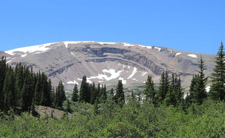
Horseshoe Mountain is named for the huge, curved cirque carved into its east face, which you can see clearly from the road below. It sits in the southern Mosquito Range west of Fairplay. The standard way up follows old mining roads almost all the way to the saddle between Horseshoe and Peerless Mountain, then a short ridge walk south to the top. The round trip is about 8 miles with about 2,300 feet of gain.
This is one of the easier high 13ers. The walking is Class 1 on gravel road, chiprock and tundra, with no exposure. It is a good family hike or a first 13er. The main dangers are the strong winds this range is known for, afternoon lightning, and old mine ruins along the way.
Most parties take 4 to 6 hours. Much of the land along the road is old private mining claims; stay on the road and leave any old buildings and equipment alone.
Plan of the day
Start by
By 6 a.m. The road is above treeline almost the whole way, and the ridge to the summit is wide open to wind and storms.
Turnaround
If you are not at the Horseshoe and Peerless saddle by 11 a.m., or thunderheads are building to the west, turn back.
Crux
Nothing technical. The hardest part is the long, steady road grade and some tedious chiprock and small rubble near the saddle.
Route-finding
Easy. The old road switchbacks many times but always leads up toward the Peerless Mine and the saddle. A path follows the ridge from the saddle to the summit. Side roads branch off to old mines; stay on the main road heading for the saddle.
Water
Fourmile Creek runs near the start, and there are small streams low on the route. There is no water on the upper road or ridge. Bring what you need and filter anything you collect.
From the junction of US 285 and Highway 9 in Fairplay, drive south on US 285 about 1 mile and turn west onto County Road 18 (Fourmile Creek Road). After about 4 miles you enter national forest. Continue west past the Horseshoe and Fourmile campgrounds. About 2.5 miles past the Fourmile campground turnoff you reach the old mining town site of Leavick, where some old buildings still stand.
Most cars can continue about 0.75 miles past Leavick to where a 4WD road turns off to the left near 11,600 feet. There is a small parking area just before the turnoff; this is where the route starts. High-clearance 4WD vehicles can drive farther up the mining road, as high as about 13,200 feet, which shortens the hike a lot. Respect any private property signs along the road.
RoadTundraTalus and screeRidgeExposed to lightning
The line is elevation, the band underneath is the ground, and the numbered dots match the steps below. Mileage and elevations are approximate.
1
4WD road turnoff above Leavick 11,600' · 0 mi
Start at the small parking area where the 4WD road branches left from the Fourmile Creek road. The big curved cirque of Horseshoe is in view to the west. Walk up the 4WD road.
2
Lower road 11,800' · 0.5 mi
The road climbs through open ground above the valley floor. Old mining claims line the area. Stay on the road.
Watch for: Private mining land; stay on the road.
3
First switchbacks 12,000' · 1 mi
The road starts to turn back and forth often. Views open up of the horseshoe-shaped cirque and the two small lakes tucked beneath it.
4
Above treeline 12,200' · 1.5 mi
You are now fully above treeline on open slopes. The road surface is gravel and chiprock. Keep following the main road uphill and ignore spur roads.
Watch for: Side roads lead to old mines; stay on the main road.
5
Mining ruins 12,600' · 2.1 mi
Around 12,600 feet you start passing old mine buildings, tailings piles and rusted equipment.
Watch for: Stay out of old mine openings and away from collapsing structures.
6
Upper switchbacks 12,900' · 2.6 mi
The road keeps switchbacking up the slope toward the high ridge between Horseshoe and Peerless. The footing gets looser with small rubble.
7
Peerless Mine 13,100' · 3 mi
Pass the remains of the Peerless Mine below the saddle. Peerless Mountain is the rounded bump to the north.
8
Horseshoe and Peerless saddle 13,250' · 3.3 mi
Reach the saddle on the ridge. The wind often picks up sharply here. Turn left (south) and follow the path along the ridge toward Horseshoe.
Watch for: Strong wind is common from here to the top.
9
Ridge south 13,600' · 3.7 mi
Walk the broad ridge on tundra mixed with chiprock and scree. The rim of the cirque drops away to your left. Stay back from the edge.
Watch for: Do not get close to the cornice or rim early in the season.
10
Horseshoe Mountain summit 13,918' · 4 mi
The top is broad and flat. Look down into the great horseshoe-shaped cirque to the east. Sheridan, Sherman and the other Mosquito peaks lie to the north.
Along the route
Horseshoe Mountain and its cirque · Photo: Jeffrey Beall
Here a road goes off straight ahead. Turn right to follow the road.
Coming down: Turn left to stay on the trail you came up. Don’t take the road.
2Mile 3.0 · 13,100'
Keep right to stay on Peerless Mountain Road
Here an unmarked path goes off to the right; a road goes off to the left; an unmarked path goes off straight ahead; an unmarked path goes off to the right. Keep right to follow Peerless Mountain Road.
Coming down: Keep left to stay on Peerless Mountain Road. Don’t take the unmarked path or the road.
3Mile 3.8 · 13,710'
Turn left
Here an unmarked path goes off to the right. Turn left to follow the trail.
Coming down: Turn right to stay on the trail you came up. Don’t take the unmarked path.
Landmarks to know
The old buildings at the Leavick town site.
The small parking area at the 4WD road turnoff near 11,600 feet.
The curved cirque of Horseshoe and its two small lakes seen from the road.
Old mine ruins starting around 12,600 feet.
The Peerless Mine remains just below the saddle.
The saddle between Horseshoe and Peerless, where you turn south.
The edge of the cirque on your left as you walk the summit ridge.
Getting down
Most people return the way they came: north along the ridge to the saddle, then back down the old road. The road is easy to follow, but take care on loose chiprock on the steeper switchbacks. Do not cut switchbacks through the mine areas.
A Class 2 option goes south from the summit past where the broad east ridge meets the south ridge, then east-southeast down talus and scree into the basin. Stay near the middle of the drainage to avoid short, rocky gullies. From the lower basin near 12,400 feet, walk north-northeast across tundra and some willows, passing east of the two lakes, cross the outlet stream of the northern lake, and rejoin the road near 12,000 feet. Only use this way in clear weather and if you can read the terrain.
If things go wrong
The road is the bail route from anywhere. From the ridge, go back to the saddle and down the road; do not try to drop straight into the cirque, which is steep and cliffy. If lightning starts, get off the ridge first, then keep moving down the road and away from high points and metal mining debris. If someone is hurt, the road allows high-clearance vehicles to get fairly high, which helps rescuers. Call 911 if you have a signal.
3D flyover
Press play to fly the East Slopes. The graph shows elevation along the way and how much you gain each mile. Open full screen.
For planning only. The line is traced from open map data, not walked in the field, and off-trail parts are drawn straight. Load it in your GPS app to see the route, but navigate with your eyes, a map and the route description.
See the trail on video
A climb of this route filmed by Ethan Powell. The video belongs to them and only plays when you press play.
Jump to
Other routes
Every way up Horseshoe Mountain we list, with its class.
This describes the route on a dry summer day. Snow, ice, a washed-out road or an afternoon storm can make it a very different climb. Check recent conditions the week you go and turn around when the day tells you to.