Afternoon storm risk is the line that matters. Everything else is comfort. In summer, plan to be off the ridge before the build-up starts, not as it starts. Forecast for the summit point, adjusted for its elevation · data from Open-Meteo.
Standard route · Northwest Ridge
Overview
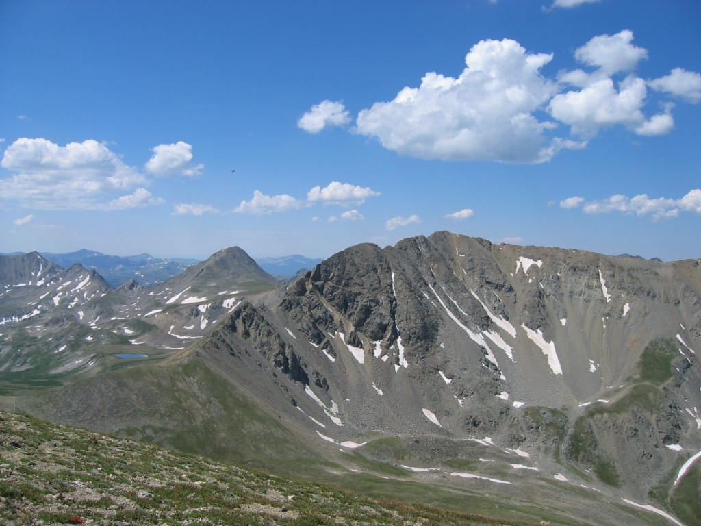
Missouri Mountain sits at the head of Missouri Gulch in the Sawatch Range, next to Belford and Oxford. The Northwest Ridge route follows the Missouri Gulch trail up through the forest and into a wide alpine basin, then switchbacks up to a saddle and follows a narrow ridge to the summit. It is Class 2, about 10.5 miles round trip with 4,500 feet of gain.
The trail is good almost the whole way. The first mile is a steep climb up forest switchbacks, and the upper slopes are rocky and loose. The one tricky spot is on the summit ridge, where the trail drops about 25 feet off the right side of the crest to get around rocky towers. That short stretch is harder Class 2, with loose rock and a big drop below.
Most people take 7 to 9 hours. It suits hikers who have done a few Class 2 peaks and are fine with some exposure. The ridge is narrow and open for the last half mile, so lightning is the main danger. Snow on the ridge or in the bypass early in the season can make the route much more serious.
Plan of the day
Start by
By 5 a.m. You are above treeline for about 3 miles each way, and storms often build over the Sawatch by late morning.
Turnaround
If you have not reached the 13,700-foot saddle by 10:30 a.m., or clouds are building, turn around there. The ridge beyond is narrow, exposed, and slow to retreat from.
Crux
The short bypass about two-thirds of the way along the summit ridge, where the trail drops about 25 feet down the right side of the crest to get past rocky towers. It is loose, steep, and exposed.
Route-finding
Easy on a clear day. Stay right at the Belford junction at 11,600 feet, and turn right onto the Missouri Mountain Trail at 12,600 feet. The upper route is not obvious from the basin, so trust the trail.
Water
Missouri Gulch creek runs along the lower trail and through the basin to about 12,000 feet. Filter or treat all water. Above the 12,600-foot junction there is no water, so fill up before you climb.
Standard 2WD dirt parking lot located directly off Chaffee County Road 390.
Terrain
Tight, brutally steep dirt switchbacks opening into a massive alpine valley and barren ridges.
You start with an immediate, lung-burning climb up dozens of tight dirt switchbacks hidden in a dark, steep forest. After gaining 1,000 feet of rapid elevation, you break out into a massive, stunning mountain valley cradled by three separate 14ers. Turning left for Belford pits you against a relentlessly steep, crumbling dirt and scree trail that snakes straight up the mountain's face. Once on Belford, looking toward Oxford reveals a massive, barren ridge resembling a giant dirt moonscape. You simply hike down a wide rock saddle and march right up a straightforward, rocky path to tag Oxford.
Chaffee County Road 390 leaves U.S. 24 between Leadville and Buena Vista. Coming from Leadville, it is about 20 miles along the highway heading south; turn right. Coming from Buena Vista, it is 14.5 miles heading north; turn left.
County Road 390 is a good dirt road that normal cars handle fine. After 7.5 miles you will see the Missouri Gulch trailhead sign. Make a left there and head down to the big lot, where restrooms are available. Because Belford and Oxford hikers share it, the lot can fill on summer weekends. The route enters the Collegiate Peaks Wilderness, so wilderness rules apply.
Trail in the treesTundraTalus and screeRidgeExposed to lightning
The line is elevation, the band underneath is the ground, and the numbered dots match the steps below. Mileage and elevations are approximate.
1
Missouri Gulch trailhead 9,650' · 0 mi
From the lot, follow the Missouri Gulch trail and cross the bridge over Clear Creek. The trail enters the forest right away.
2
Forest switchbacks 9,900' · 0.3 mi
After a little over a quarter mile, the trail starts a long series of steep switchbacks up through the trees. This is hard work early in the day, so settle into a steady pace.
3
Above the switchbacks 10,400' · 1 mi
Near 10,400 feet the switchbacks end and the trail heads south up Missouri Gulch, with the creek below on your left.
4
Log bridge 10,800' · 1.4 mi
At about 10,800 feet, turn left and cross the creek to its east side on a rough log bridge. Turn right on the far side and head south through an open area.
Watch for: The logs can be wet and slick.
5
Old cabin ruins 11,200' · 1.8 mi
Back in the trees, you pass the ruins of an old cabin. Treeline is just ahead.
6
Treeline 11,300' · 2 mi
Leave the forest near 11,300 feet. The trail heads south up the open gulch, with Belford rising on the left and Missouri Mountain ahead.
7
Belford junction 11,600' · 2.3 mi
At 11,600 feet the Belford trail branches off to the left. Stay right on the Missouri Gulch / Elkhead Pass trail. Missouri fills the view to the south, but its summit is hard to pick out.
Watch for: Do not take the Belford trail by mistake.
8
Basin and creek crossing 12,000' · 2.9 mi
The trail runs through willows, crosses the stream again, and climbs over a small hill in the basin. Keep heading south.
9
Missouri Mountain Trail junction 12,600' · 3.6 mi
At 12,600 feet, reach a junction. The main trail keeps going toward Elkhead Pass. Turn right onto the Missouri Mountain Trail and start switchbacking up the slope to the west.
Watch for: Easy to walk past. If you are heading toward the low pass at the head of the basin, you missed it.
10
Level area 12,900' · 3.9 mi
Near 12,900 feet the slope levels out as the trail approaches Point 13,784, a bump on the ridge above. Follow the trail northwest to the base of a rough talus slope.
11
Talus traverse 13,300' · 4.2 mi
The trail crosses the south side of Point 13,784 on talus, then zigzags up toward the saddle. Stay on the trail; the slope around it is loose.
Watch for: Loose rock. Watch for rocks knocked down by people above.
12
13,700-foot saddle 13,700' · 4.5 mi
Reach the saddle between Point 13,784 and Point 13,930. Turn left onto Missouri's northwest ridge.
Watch for: Check the weather. The ridge from here is narrow and exposed.
13
Ridge crest 13,950' · 4.8 mi
Pass along the west side of Point 13,930 and climb onto the ridge crest. The summit finally comes into view ahead. Stay on the trail along the crest.
14
Ridge bypass 13,950' · 5 mi
About two-thirds of the way along the ridge, rocky towers block the crest. The trail drops about 25 feet down the right side to get around them, then climbs back up. Go slowly and use your hands.
Watch for: Difficult Class 2 with a steep drop below. Loose rock and dirt. Dangerous if snowy or icy.
15
Summit 14,071' · 5.25 mi
After the bypass, follow the trail up the last stretch of ridge to the narrow summit. Belford and Oxford are close to the northeast, and Huron is to the southwest.
Here Mount Belford - Missouri Gulch Trail goes off to the left. Keep going straight on Missouri Gulch Trail.
Coming down: Keep going straight on Missouri Gulch Trail. Don’t take Mount Belford - Missouri Gulch Trail.
2Mile 4.6 · 13,780'
Turn left to stay on Missouri Mountain Northwest Ridge
Here Missouri Mountain West Ridge goes off to the right. Turn left to follow Missouri Mountain Northwest Ridge.
Coming down: Turn right to stay on Missouri Mountain Northwest Ridge. Don’t take Missouri Mountain West Ridge.
Landmarks to know
Bridge over Clear Creek at the trailhead
Log bridge across the gulch creek at about 10,800 feet
Old cabin ruins just below treeline
Belford trail junction at 11,600 feet (stay right)
Missouri Mountain Trail junction at 12,600 feet (turn right)
Point 13,784 with the trail traversing its south side
The 13,700-foot saddle (turn left onto the ridge)
Rocky towers on the ridge crest, bypassed on the right
Getting down
Return the same way. Take the ridge bypass slowly: going back, the drop is on your left, and the loose dirt is easy to slip on. At the 13,700-foot saddle, turn right and follow the trail back down across the south side of Point 13,784. Do not try to shortcut down the steep slopes into the basin; they are loose and much steeper than they look.
Once in the basin, rejoin the main trail at the 12,600-foot junction and turn left (north) down the gulch. Stay on the main trail past the Belford junction. The steep forest switchbacks at the bottom are hard on tired knees. Take care on the log bridge.
If things go wrong
The saddle at 13,700 feet is the key decision point. If weather is building, turn back there. If a storm hits on the ridge, go back to the saddle and down the trail to the basin as fast as you safely can; do not try to drop off the ridge on untested slopes. The basin below 12,600 feet is safer ground, and the trees below 11,300 feet offer the first shelter. The trailhead is about 5 miles from the summit. If someone is hurt, keep them warm and still, send someone for help if needed, and call 911 if you can get a signal.
3D flyover
Press play to fly the Northwest Ridge. The graph shows elevation along the way and how much you gain each mile. Open full screen.
For planning only. The line is traced from open map data, not walked in the field, and off-trail parts are drawn straight. Load it in your GPS app to see the route, but navigate with your eyes, a map and the route description.
See the trail on video
A climb of this route filmed by The Virtual sherpa. The video belongs to them and only plays when you press play.
Jump to
Other routes
All 4 routes up Missouri Mountain, with the class and round-trip distance for each.
Expect talus, scree and stretches where the trail disappears. Ankles and weather cause most of the trouble here. Start early, keep an eye on the sky, and set a turnaround time before you leave the car.