Afternoon storm risk is the line that matters. Everything else is comfort. In summer, plan to be off the ridge before the build-up starts, not as it starts. Forecast for the summit point, adjusted for its elevation · data from Open-Meteo.
This is a snow climb. It is only safe when the snow is firm and stable, usually early in the morning in late spring and early summer. You need an ice axe, crampons, a helmet and the skills to use them. Check avalanche conditions before you go.
Snow route · North Face
Overview
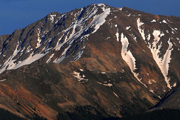
The North Face route is a spring snow climb on La Plata Peak. It climbs through La Plata Basin to a long, narrow couloir on the steep north face, which leads close to or right onto the summit. It is about 8.75 miles round trip with about 4,500 feet of gain.
This is not the winter version of the standard hike. It is a snow climb, rated Difficult Class 2 with moderate snow. It needs an ice axe, crampons and a helmet, and the skills to use them. It suits climbers who have done some snow routes and can judge avalanche conditions. The standard northwest ridge route is a much easier hike.
Plan on 8 to 11 hours. Start early so the snow is firm while you climb.
Plan of the day
Start by
By 3 or 4 a.m. You want to be in the couloir while the snow is frozen and firm.
Turnaround
If you are not in the couloir by about 8 a.m., or the snow is getting soft and wet, turn around. Soft spring snow can slide.
Crux
The narrow main couloir from about 13,000 feet to the summit, especially the steeper upper part.
Route-finding
Hard. You leave the trail near 10,900 feet with no path to treeline. From the upper basin the face is confusing. Find the summit first. The main couloir is almost straight between you and the top.
Water
South Fork Lake Creek, and the La Plata Gulch stream near the start. None higher up. Bring a way to keep water from freezing.
Just south of Leadville, leave U.S. 24 and head west on Colorado 82 toward Twin Lakes. After about 14.6 miles, the signed La Plata Peak trailhead and parking area are on the left.
Trail in the treesOff-trail, no set pathTundraTalus and screeSnow or couloirExposed to lightning
The line is elevation, the band underneath is the ground, and the numbered dots match the steps below. Mileage and elevations are approximate.
1
La Plata Peak trailhead 10,000' · 0 mi
Walk down the South Fork Lake Creek road about 100 yards and cross a vehicle bridge. After about a quarter mile on the road, look left for a trail sign.
2
South Fork Lake Creek bridge 10,050' · 0.6 mi
Take the trail east into the forest and over the creek on a bridge. Then make a sharp right turn uphill.
3
La Plata Gulch crossing 10,150' · 1 mi
About a third of a mile on, a small log bridge takes you over the La Plata Gulch stream. Go right and take the trail up beside the stream.
4
Steps through the forest 10,700' · 1.5 mi
Between about 10,400 and 10,700 feet the trail is steep with log and stone steps. If snow hides the trail, climb south on the easiest ground along the gulch's east side.
5
Leave the trail 10,900' · 1.8 mi
Near 10,900 feet, the La Plata trail is left behind. Climb southeast through steep forest, leaving the gulch behind. Your goal is the northwest ridge at treeline.
Watch for: No trail from here to treeline. Use a map or GPS.
6
Headwall at treeline 11,800' · 2.4 mi
The slope eases as you near treeline. A big clearing opens up under a headwall on the northwest ridge. Turn left before the headwall.
7
Entering La Plata Basin 11,900' · 2.7 mi
Head east along the talus at the base of the ridge, then south-southeast toward the upper basin. Only drop lower to the left if avalanche risk on the slopes to your right makes it necessary.
Watch for: Watch the slopes above you for avalanche signs.
8
Narrow part of the basin 12,200' · 3.1 mi
Move into the middle of the basin and follow the drainage up. Past a narrow spot at 12,200 feet, the north face opens up ahead.
Watch for: Stop and pick out the main couloir. It is partly hidden and there are other couloirs to either side.
9
Couloir entrance 13,000' · 3.7 mi
Head south to the face. Near 13,000 feet, cut southwest into the couloir and start climbing.
Watch for: Put on crampons and helmet before entering.
10
Main couloir 13,650' · 4.1 mi
Branches split off to the right. Stay left in the narrow main couloir. Near 13,650 feet, do not drift right onto the broken upper face.
11
Couloir split 14,000' · 4.3 mi
Above 14,000 feet the couloir divides. The left branch reaches the ridge near 14,250 feet. The right branch goes straight to the summit.
12
La Plata Peak summit 14,344' · 4.4 mi
Take the right branch to top out on the summit.
Getting down
Hikers should not go back down the couloir. Instead, descend the northwest ridge, the standard route. Follow the crest down to about 12,700 feet, where the standard trail leaves the ridge to the west. If the ridge's west side has little snow, go down by the standard route. If the west side might slide, stay on the northwest ridge for almost a mile north to the top of the headwall above treeline. Find a way down the headwall and follow your morning route back through the trees to the trailhead.
If things go wrong
Below the couloir, go back the way you came through the basin and the forest. Once in the couloir, retreating means downclimbing steep snow facing in. If the snow turns soft or unstable, get out of the couloir early. In an emergency call 911 if you have signal.
Other routes
Every way up La Plata Peak we list, with its class.
This describes the route in its usual season. Distances and elevations are close estimates for planning. Snow, ice, rockfall, a washed-out road or an afternoon storm can make it a very different climb. Check recent conditions the week you go and turn around when the day tells you to.